


Burn bans in effect as of Sept. 12th, 2025
We've been quite dry for many of us recently, but that changed for some of us last week. The heavy rain across south central Kentucky allowed for judges to rescind the burn bans that were in play for Hart, Green, Taylor, and Adair counties. Henry County was also able to drop its burn ban. In southern Indiana, Orange and Washington counties were placed under burn bans.

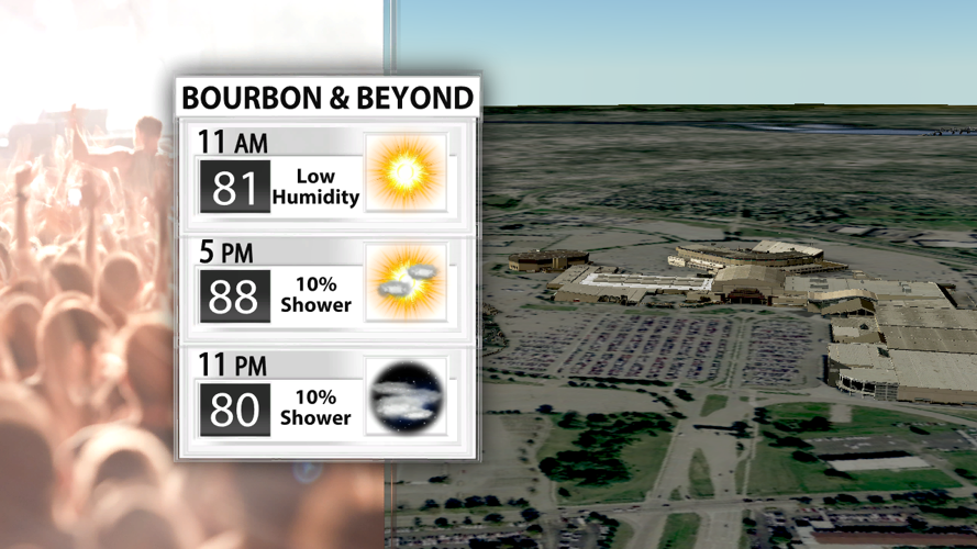
Bourbon & Beyond forecast for Saturday
A ridge of high pressure is building to our west and moving in the weekend. Disturbances or areas of energy called a vorticity maximum will ride along the periphery of this ridge. A vort max is expected to dive south from northern Indiana to central Kentucky on Saturday. While there isn't a ton of moisture in the afternoon, this area of lift could be enough to pop off some showers and storms in the late afternoon and evening. That's why we have included a 10% chance for showers/storms on Saturday with the best chance existing across southern Indiana.

SPC Wind Threat Sept. 13th, 2025
Storms on Saturday could pack a punch with a 5% chance for damaging winds. This will likely be confined to the far northern reaches of our viewing area.

AdvanceTrak shows showers and storms Sunday morning
The same ridge will also throw another vort max or two across our area early on Sunday. Therefore, showers and storms will be possible again. But just like Saturday, there won't be much moisture to work with. That's why we'll keep rain chances down at 20% on Sunday.

NAM rainfall totals
Rainfall isn't expected to be widespread at this time, and rainfall totals will likely stay on the lower end of the scale if you do receive rain. We'll leave the door open to the possibility of a few downpours that could drop meaningful rain either day this weekend.


