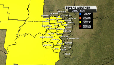

A tornado watch has been posted for part of our area for storms arriving later this evening and tonight. The watch is in effect until 12AM EDT tonight. This does include the Louisville metro area. Here are the other counties that are included:

Here's more info from the Storm Prediction Center on the watch:
* Primary threats include...
A few tornadoes possible
Scattered damaging wind gusts to 70 mph possible
Scattered large hail events to 1.5 inches in diameter possible
SUMMARY...A band of severe thunderstorms is expected to move
eastward across the watch area from late afternoon into this
evening. These storms may produce a few tornadoes, scattered wind
damage, and hail.
The tornado watch area is approximately along and 70 statute miles
north and south of a line from 70 miles west southwest of Evansville
IN to 20 miles south of Louisville KY. For a complete depiction of
the watch see the associated watch outline update (WOUS64 KWNS
WOU8).
PRECAUTIONARY/PREPAREDNESS ACTIONS...
REMEMBER...A Tornado Watch means conditions are favorable for
tornadoes and severe thunderstorms in and close to the watch
area. Persons in these areas should be on the lookout for
threatening weather conditions and listen for later statements
and possible warnings.


