

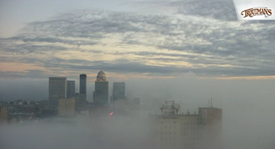
We saw some thick fog develop along the Ohio River in the Downtown Louisville area this morning, so let's look at how fog forms and why not everyone sees it.

Fog is a collection of liquid water droplets or ice crystals suspended in the air at or near the Earth's surface. While fog is a type of cloud, the term "fog" is typically distinguished from the more generic term "cloud" in that fog is low-lying, and the moisture in the fog is often generated locally (such as from a nearby body of water, like a lake or the ocean, or from nearby moist ground or marshes). This is why communities near the Ohio River, small ponds, or other moist, low-lying areas typically see more fog than communities in the heart of the city.
There are several different types of fog, and each forms a little differently, so today we will stick to the two most common types in our area:
Radiation fog is formed by the cooling of land after sunset by thermal radiation in calm conditions with a clear sky.
Advection fog occurs when moist air passes over a cool surface by advection (wind) and is cooled. It is most common at sea when moist air encounters cooler waters, including areas of cold water upwelling. This is most common here over the Ohio River or larger lakes.
Steam Fog forms when water vapor is added to air that is much colder, then condenses into fog. It is commonly seen as wisps of vapor emanating from the surface of water. This fog is most common in middle latitudes near lakes and rivers during autumn and early winter, when waters are still warm and colder air masses prevail. A strong inversion confines the upward mixing to a relatively shallow layer within which the fog collects and assumes a uniform density. Under these conditions, the visibility is often 3/16 mile (300 meters) or less.


