(FOX NEWS) -- As the coronavirus outbreak prompts new measures to prevent it from becoming a pandemic, experts have created a map that tracks and visualizes its global spread.
The map, which was produced by researchers from Johns Hopkins University, uses data from the Centers for Disease Control and Prevention, the World Health Organization, China's CDC, and other sources.
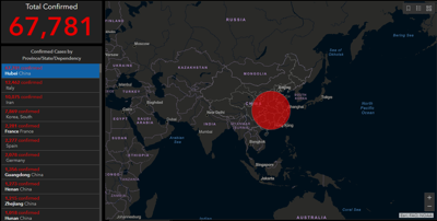
The map shown below tracks the total number of confirmed cases, the total deaths and the total recoveries -- all in real time. Clicking on one of the larger red dots shows the severity of the outbreak in each particular region.

Along the left side of the map, you can click each country that has reported cases to see their location.
This type of map could help to stem the tide of false or panic-inducing information that has spread since the outbreak's start in December.
Copyright 2020 WDRB Media and Fox News. All rights reserved.


