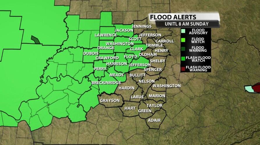
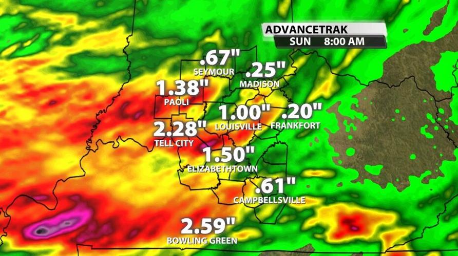
A Flash Flood Watch has been issued for part of our area Saturday night through Sunday morning. The Watch is valid through 8 AM Sunday as another round of strong storms with heavy rain will move through overnight. By 2 AM or 3 AM the storms should be winding down enough to see where flash flooding will be an issue. When you wake up Sunday morning to go to church or brunch, most of the flash flooding should be fading away.

Not everyone will see flash flooding from the storms that pass through overnight. If you saw heavy rain Saturday morning, and there is still standing water in your neighborhood, you are most at risk for flash flooding. Additionally if you live west of I-65 and near or north of I-64, you are likely to see the stronger storms overnight with heavier rain.

Below is the text issued by the National Weather Service with this Watch:
THE FLASH FLOOD WATCH CONTINUES FOR

* PORTIONS OF INDIANA AND KENTUCKY, INCLUDING THE FOLLOWING AREAS,
  IN INDIANA, CLARK, CRAWFORD, DUBOIS, FLOYD, HARRISON, ORANGE,
  PERRY, SCOTT AND WASHINGTON. IN KENTUCKY, BRECKINRIDGE, HANCOCK,
  JEFFERSON, MEADE AND OHIO.

* THROUGH SUNDAY MORNING.

* ROUNDS OF SHOWERS AND THUNDERSTORMS WITH INTENSE RAINFALL RATES
  ARE EXPECTED LATER TODAY AND INTO SUNDAY MORNING ACROSS THE WATCH
  AREA. RAIN AMOUNTS COULD RANGE FROM 2 TO 4 INCHES WITH LOCALLY
  HIGHER AMOUNTS FROM SLOW MOVING SHOWERS AND STORMS.

* A FLASH FLOOD WATCH MEANS THAT CONDITIONS MAY DEVELOP THAT LEAD TO
  FLASH FLOODING. FLASH FLOODING IS A VERY DANGEROUS SITUATION.


