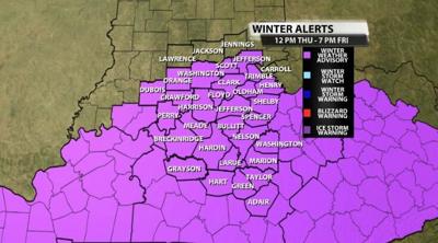

The National Weather Service has issued a new Winter Weather Advisory for nearly our entire area on Thursday. A wintry mix will start in our southern communities Thursday afternoon with snow and some freezing rain before transitioning to snow and filling in to the north through the evening. Tune into WDRB News through the evening to see our latest forecast updates. We're live from 4-7 PM and again 10-11:30.
Below is the text issued with the Advisory:
...WINTER WEATHER ADVISORY IN EFFECT FROM NOON EST /11 AM CST/
THURSDAY TO 7 PM EST /6 PM CST/ FRIDAY...
* WHAT...An initial wintry mix of snow and some freezing rain is
expected Thursday afternoon with a short period of freezing
drizzle Thursday evening. Widespread light to moderate snow is
expected late Thursday night and through the day on Friday.
Total snowfall accumulations of 1 to 3 inches with a small glaze
of icing will be possible across southern Indiana and northern
portions of Kentucky.
* WHERE...Southern Indiana and the northern half of Kentucky.
* WHEN...From noon EST /11 AM CST/ Thursday to 7 PM EST /6 PM
CST/ Friday.
* IMPACTS...Plan on slippery road conditions. The hazardous
conditions could impact the Thursday evening commute and will
likely result in negative travel impacts Thursday night and
through the day on Friday.
PRECAUTIONARY/PREPAREDNESS ACTIONS...
Slow down and use caution while traveling.
In Indiana, for Indiana Road Conditions please visit
http://pws.trafficwise.org In Kentucky, for Kentucky Road
Conditions please visit http://goky.ky.gov


