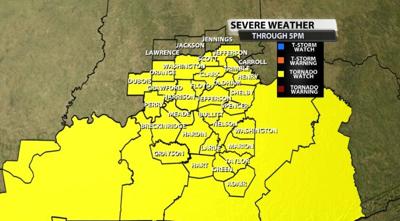
The Storm Prediction Center has expanded a Tornado Watch across our area until 5 PM.

We will have updates for you on these storms online and on WDRB TV through the day. Below is the text issued with the Watch:
The NWS Storm Prediction Center has issued a

   * Tornado Watch for portions of
     Far southeast Illinois
     Southern Indiana
     Kentucky

   * Effective this Friday afternoon from 1210 PM until 500 PM EST.

   * Primary threats include...
     A few tornadoes likely with a couple intense tornadoes possible
     Widespread damaging winds and isolated significant gusts to 85
       mph likely

   SUMMARY...Low-topped supercells embedded within broken line segments
   will sweep east-northeast across the Lower Ohio Valley and Kentucky
   through this afternoon. Tornadoes and damaging winds are the primary
   hazards.

   The tornado watch area is approximately along and 90 statute miles
   east and west of a line from 25 miles north northwest of Louisville
   KY to 65 miles east southeast of Bowling Green KY. For a complete
   depiction of the watch see the associated watch outline update
   (WOUS64 KWNS WOU2).

   PRECAUTIONARY/PREPAREDNESS ACTIONS...

   REMEMBER...A Tornado Watch means conditions are favorable for
   tornadoes and severe thunderstorms in and close to the watch
   area. Persons in these areas should be on the lookout for
   threatening weather conditions and listen for later statements
   and possible warnings.


