The NWS Storm Prediction Center has issued a

   * Tornado Watch for portions of
     Southern Illinois
     Western into Central Kentucky
     Southeast Missouri
     Northwest into Middle Tennessee

   * Effective this Friday afternoon and evening from 110 PM until
     800 PM CDT.

   * Primary threats include...
     A couple tornadoes possible
     Scattered damaging wind gusts to 70 mph possible
     Isolated large hail events to 1 inch in diameter possible

   SUMMARY...Scattered thunderstorms are forecast to develop and
   intensify this afternoon as the low-level wind profile strengthens
   across the Watch area.  A couple of supercell tornadoes are
   possible, in addition to damaging gusts with the stronger storms.

   The tornado watch area is approximately along and 60 statute miles
   north and south of a line from 50 miles southwest of Cape Girardeau
   MO to 15 miles south southeast of Bowling Green KY. For a complete
   depiction of the watch see the associated watch outline update
   (WOUS64 KWNS WOU6).

   PRECAUTIONARY/PREPAREDNESS ACTIONS...

   REMEMBER...A Tornado Watch means conditions are favorable for
   tornadoes and severe thunderstorms in and close to the watch
   area. Persons in these areas should be on the lookout for
   threatening weather conditions and listen for later statements
   and possible warnings.
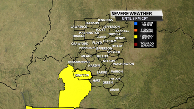
THE NATIONAL WEATHER SERVICE HAS ISSUED TORNADO WATCH 376 IN
EFFECT UNTIL 8 PM CDT THIS EVENING FOR THE FOLLOWING AREAS

IN KENTUCKY THIS WATCH INCLUDES 7 COUNTIES

IN CENTRAL KENTUCKY

GRAYSON               OHIO

IN SOUTH CENTRAL KENTUCKY

BUTLER                EDMONSON              LOGAN
SIMPSON               WARREN
Reach meteorologist Matthew Wine at mwine@wdrb.com, on Twitter or on Facebook. Copyright 2025. WDRB Media. All rights reserved.


