
UPDATE: This Tornado Watch has been expanded to include more of our area.
A Tornado Watch has been issued for several of our southern counties as strong storms move through northern Tennessee and southern and western Kentucky. This Watch continues Midnight Eastern (11 PM CST) and means that the ingredients exist for tornadoes to develop. We will continue to monitor storms for tornadic potential.

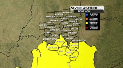
Below is the text issued with the Watch:
   The NWS Storm Prediction Center has issued a

   * Tornado Watch for portions of
     Southeast Arkansas
     Western and Central Kentucky
     Northern Mississippi
     Western and Middle Tennessee

   * Effective this Saturday morning and evening from 1135 AM until
     700 PM CST.

   * Primary threats include...
     A few tornadoes likely
     Scattered damaging wind gusts to 70 mph possible
     Isolated large hail events to 1 inch in diameter possible

   SUMMARY...Strong to severe thunderstorms will continue to develop
   and increase through early afternoon near an eastward-moving cold
   front, with additional/more isolated development also possible ahead
   of it later this afternoon. Increasingly low-level moisture and
   strong shear will support the potential for severe storms including
   a few tornadoes.

   The tornado watch area is approximately along and 85 statute miles
   east and west of a line from 30 miles north of Bowling Green KY to 5
   miles east southeast of Monticello AR. For a complete depiction of
   the watch see the associated watch outline update (WOUS64 KWNS
   WOU4).

   PRECAUTIONARY/PREPAREDNESS ACTIONS...

   REMEMBER...A Tornado Watch means conditions are favorable for
   tornadoes and severe thunderstorms in and close to the watch
   area. Persons in these areas should be on the lookout for
   threatening weather conditions and listen for later statements
   and possible warnings.


