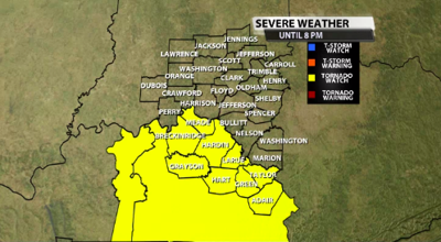
The National Weather Service in Louisville has issued a TORNADO WATCH for a portion of our viewing area. This is mainly our southern communities around and south of the Parkways. The watch is in effect until 8 pm EDT. Below is an image of the counties included in the watch.

SUMMARY...
A squall line should progress northeast across from southwest Kentucky and middle Tennessee. Brief tornadoes will remain possible within it, along with a risk for damaging winds. A Tornado Watch for portions of western and central KY. Effective this Friday afternoon and evening from 1:00 PM CDT until 7:00 PM CDT (8 pm EDT). Primary threats include: A couple tornadoes possible, scattered damaging wind gusts to 65 mph possible
PRECAUTIONARY/PREPAREDNESS ACTIONS...
REMEMBER...A Tornado Watch means conditions are favorable for tornadoes and severe thunderstorms in and close to the watch area. Persons in these areas should be on the lookout for threatening weather conditions and listen for later statements and possible warnings.


