
Mother Nature can sometimes provide amazing types of clouds. There is one type of cloud however that scientists still aren't exactly sure how it forms, and it usually forms over the Pacific Ocean. Actinoform clouds can form "trains" that are up to six times the length of the original cloud field, yet they maintain their own distinct identity.
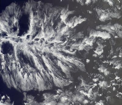
NOAA satellites captured actinoform clouds over the eastern Pacific Ocean on June 3, 2021. These collections of shallow clouds, organized in a distinctive radial pattern, often appear as leaf-like or reminiscent of wagon wheel spokes. Their name describes their shape—“actino” is derived from the Greek word for “ray” and the spoke-like structures that reach out in all directions are called “actiniae.”
Actinoform clouds generally form lower in the atmosphere (around 6,600 feet above Earth), over water, in areas where stratocumulus clouds are common. They are often spotted in the open waters of the Pacific Ocean, most commonly in the Southern Hemisphere. The clouds can last up to 72 hours and are often associated with drizzle.
These cloud formations are usually so large that it’s not possible to recognize them from below. They were first observed by NASA’s Television Infrared Observation Satellite (TIROS) V satellite in August 1962. A chain of actinoform clouds west of Peru, captured by TIROS V on October 7, 1962, was the first image featured in Monthly Weather Review’s “Picture of the Month” series in January 1963.
As early as 1961, TIROS satellites observed shallow hexagonal convective systems of cloud cells that were organized into differing degrees of cloudiness; a phenomenon that became known as “mesoscale cellular convection” or MCC. Two basic types of MCC include open- and closed-cell cloud systems, depending on whether the center of the cell is clear or cloudy. Actinoform clouds are a third class of MCC that don’t fit into either of those categories—and it’s not yet clearly understood how they form and organize into their distinctive patterns.
Satellite sensors have come a long way since actinoform clouds were first observed from space in 1962. NOAA’s latest generation of geostationary and polar-orbiting satellites capture these complex cloud formations in stunning detail.
NOAA’s geostationary satellites, GOES-16 (GOES East) and GOES-17 (GOES West), orbit 22,236 miles above Earth’s equator at the same speed Earth rotates. This means the satellites have a constant view of the same area and are able to monitor cloud formation and track clouds in motion.
NOAA’s polar-orbiting satellites, NOAA/NASA Suomi-NPP and NOAA-20, orbit from pole to pole, imaging the entire Earth at least twice daily.They are positioned just 512 miles above Earth’s surface, allowing them to capture ultra-high resolution views of actinoform clouds.
The satellites provide important data about clouds, including their height, temperature, pressure, radiative properties, and evolution over time. Studying actinoform clouds using NOAA’s advanced satellite sensors may lead to important new insights about our atmosphere.


