
Temperatures heading into Monday evening and Tuesday morning will start to trickle on down as our winds will start to come out of the North and Northwest with cold air from Canada making its way down into the area.
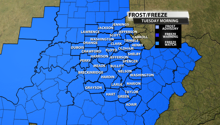
With cold air advection moving in Monday night and into Tuesday morning, temperatures could fall to the coldest we've seen it so far this season. Due to this, the NWS-Louisville has put us under a Freeze Watch for that same timeframe, and it includes all of us.
Model data backs this up pretty much no matter what model you look at. Widespread temperatures at or below freezing, with more rural areas dropping down into the upper 20s and possibly even the mid 20s would be possible.
This could end growing season for our area. The bright side is that this would really eliminate pollen season for the most part as well, which is great news for those of us still struggling with allergies this late into the year.
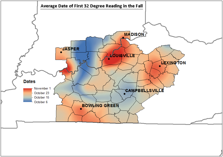
On average, our first official freeze of the year for Louisville is November 4. A freeze just means the temperature dips to 32º, but a hard freeze is a little different. A hard freeze happens when the temperature drops to 28º, and the average date for that is November 16 in Louisville. So this freeze would be a little early, but not the earliest we've ever seen. The earliest freeze in Louisville happened on October 3, 1974, and the earliest hard freeze was October 10, 1964.

In order for growing season to officially end however, the soil temperature 20in below the surface must be below 41 degrees.
Here's more from what the NWS has to say..
...HARD FREEZE POSSIBLE MONDAY NIGHT...

* WHAT...Temperatures below freezing for several hours Monday
  night, with Tuesday morning lows in the mid to upper 20s.

* WHERE...All of southern Indiana and central Kentucky.

* WHEN...From Monday evening through Tuesday morning.

* IMPACTS...Frost and freeze conditions could kill crops, other
  sensitive vegetation and possibly damage unprotected outdoor
  plumbing.


