Even though we are expecting some communities to see highs in the 90s again Thursday, that is our "break in the heat" for this week. Heat surges again Friday and we are likely to feel some of the hottest days of the year this weekend. This post will focus on an early heads up for that increased heat.
We in the WDRB Weather department try to be careful about when we use the phrase "heat wave." There is a loose scientific definition that, for our area, would mean three or more days with high temperatures at least in the upper 90s. We are expecting temperatures to set up a heat wave in our area this weekend, so let's break down which days will be most hazardous.
THURSDAY
We already mentioned Thursday being the break between Wednesday's Heat Advisory and the heat wave that will roll in this weekend. High temperatures will top out in the lower and middle 90s. We should also get a little bit of break from the humidity compared to Wednesday.
FRIDAY
As a dry cold front changes the wind direction, dew points should stay below 70 degrees, meaning not a horribly humid day. You will still notice it, but it's not completely miserable. Temperatures do start to climb again into the middle and upper 90s, but heat index values shouldn't climb above 105. That's the level that would warrant a Heat Advisory.

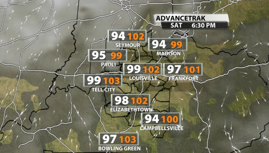
SATURDAY and SUNDAY
These are the hottest days and will likely be some of the hottest days we have felt so far this year. High temperatures will top out near 100 degrees and the humidity will start to climb. The National Weather Service has already said to expect Heat Advisories, meaning the heat index is expected to reach at least 105 for several hours in the hottest part of the afternoon.

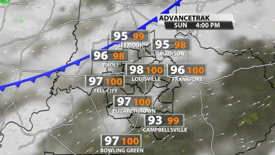
Sunday afternoon will be a smidge this oppressive compared to Saturday, but neither will feel good. Part of the danger of heat waves are the low temperatures. When temperatures don't drop much overnight, nothing (including your body) has a chance to calm itself down. This is especially dangerous for your outdoor animals and is one of the reasons we encourage you to bring them inside during these prolonged hot stretches.
The heat "breaks" Monday as more rain enters the picture and drops high temperatures from near-100 to near-90. Tune into WDRB News tonight at 10 to see the latest forecast updates and hear how humidity plays a role in this approaching heat wave.