
For a few days now we've been talking about the threat of rain and storms to start this work week. At that system gets closer, let's take a deep dive through the data so you know what to expect.
SETUP
In the big picture, a well-developed low pressure center is heading our way. There is a warm front stretched out ahead of the center of this system that will allow warmer and slightly more humid air to drift into our communities starting Monday.
The cold front won't pass through our area until Wednesday morning, so we will be dealing with rounds of rain and thunderstorms for a couple of days from this same system.
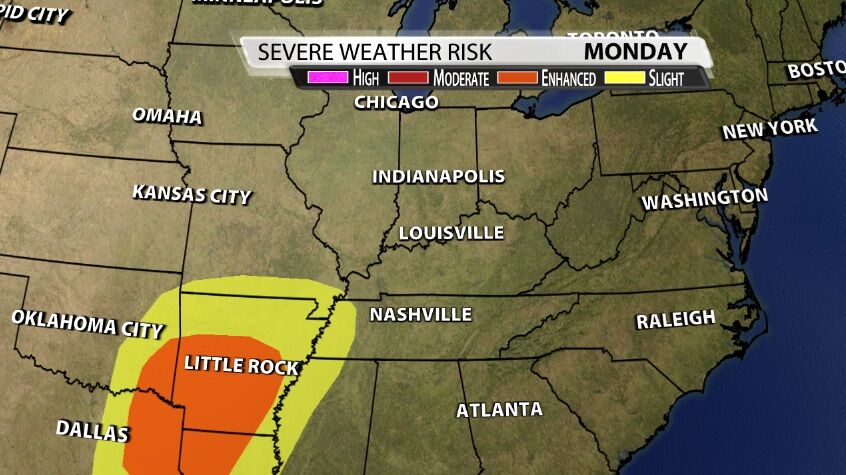
The Storm Prediction Center is currently not including our area in a risk of organized severe storms either Monday or Tuesday. Instead they are highlighting communities south and southwest of here as being most at risk of seeing the strongest storms. I (Hannah) totally agree with that since y'all often ask :) Those are the places, without question, where the storms look to be the strongest.
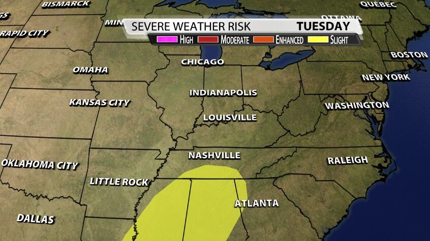
For what it's worth, I would have no problem with our southern and central communities being included in a Slight risk for Tuesday. Let's look at the data to see why I think we might be more at risk of seeing a few strong storms than these maps alone would suggest.
INGREDIENTS and THREATS
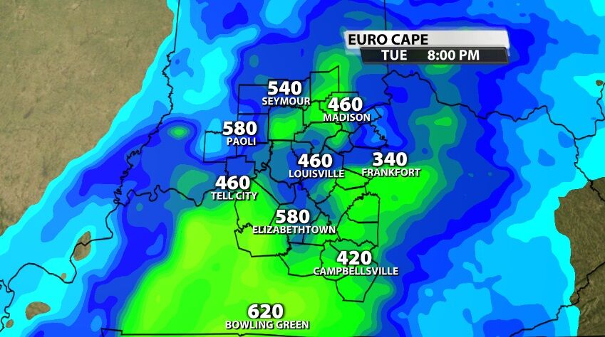
When looking for the ingredients needed to get severe weather, we generally evaluate four things: shear, lift, instability, and moisture. Know right off the bat that instability will be the limiting factor in this particular setup. Instability is what we often refer to as "storm energy" or the heat energy needed to fuel thunderstorms.
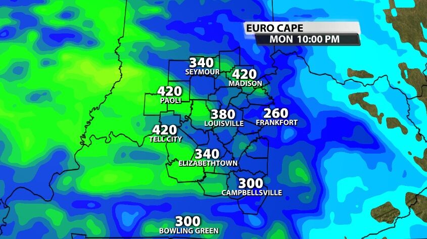
The European model shows the highest instability values (because it's biased a bit warmer in the lower levels of the atmosphere), and even these numbers are not impressive. The images above and below both show Convective Available Potential Energy (or instability) for Monday night and Tuesday night, respectively. These values night be enough to support strong storms if they developed, but that's still an "if," not a guarantee. If those storms develop, this amount of instability could support some small hail falling out of the clouds. The lack of instability in this system is the main reason some meteorologists are downplaying the storm threat, but that's just one of many factors we need to look at to make a good forecast so let's keep going.
To evaluate shear and lift, we will look at the wind at different levels of the atmosphere. When the cold front comes through early Wednesday, it will provide its own lift, but we will discuss that more in the section below on timing.
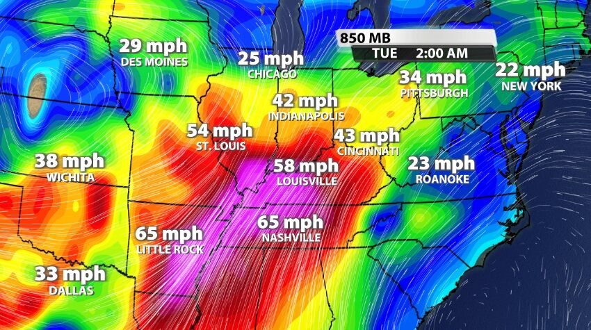
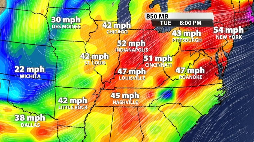
These first three images are all looking at the low level jet stream, about a mile above our heads. The image above shows the overnight hours between Monday and Tuesday when this low level jet streak will enter the space above our area. A jet streak is an area of stronger wind embedded within the overall flow pattern, and it creates rising motion in the atmosphere which storms must have to be able to grow and strengthen.
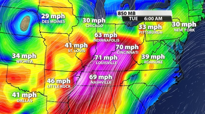
The image above shows early Tuesday morning when the wind speed will be the strongest over our area. By Tuesday night, the image below shows the wind speed has slowed a bit from its strongest earlier in the day, but it's still powerful when a new round of storms will be possible. In addition to providing some rising motion in the atmosphere, this low level jet also provides strong wind.
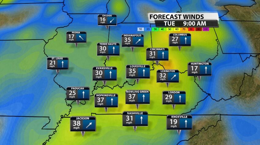
While the wind down here at the ground won't be as strong as these numbers show a mile above our heads, the strength of wind at this level and support stronger wind at the ground. This, in addition to the strong wind created on the ground by the gradient, is why strong wind gusts are likely Tuesday and early Wednesday outside of any thunderstorms that develop. Those gusts would be roughly 30-40 mph (shown in the image above); damaging wind gusts closer to 60 mph may be possible in the stronger thunderstorms.
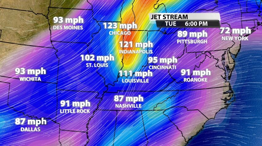
When we look all the way up at the jet stream (think of this as the level where planes fly), we see the wind moving at a different speed and from a slightly different direction than it is in the low level jet. That is the definition of shear, and we have a lot more of it the closer we look to the ground. The wind moving at different speeds and different directions can cause rotation in the atmosphere that a strong thunderstorm can harness to create a tornado. While our tornado threat is low in this setup, it is not zero. This kind of wind shear would support isolated quick, spin-up type tornadoes if any developed.
That leaves moisture as the last remaining factor, and there is a good amount of it in this system. Dewpoints are already in the 50s in our area, and we are expecting 1"-2" of widespread rain with locally higher amounts possible. Those places that see locally higher amounts may deal with some isolated flash flooding, but that shouldn't be a widespread issue across our whole area.
None of these factors are maxing out the scale, and the instability is pretty pathetic. This should not be the biggest severe weather outbreak our area has experienced, and we know lots of you are thinking back to the December 10 tornadoes. This setup does not look like that one did, not here. This is what we call a conditional setup - all these factors would need to hit their strongest at the exact same time plus a few other elements coming together for us to get widespread severe weather.
TIMING
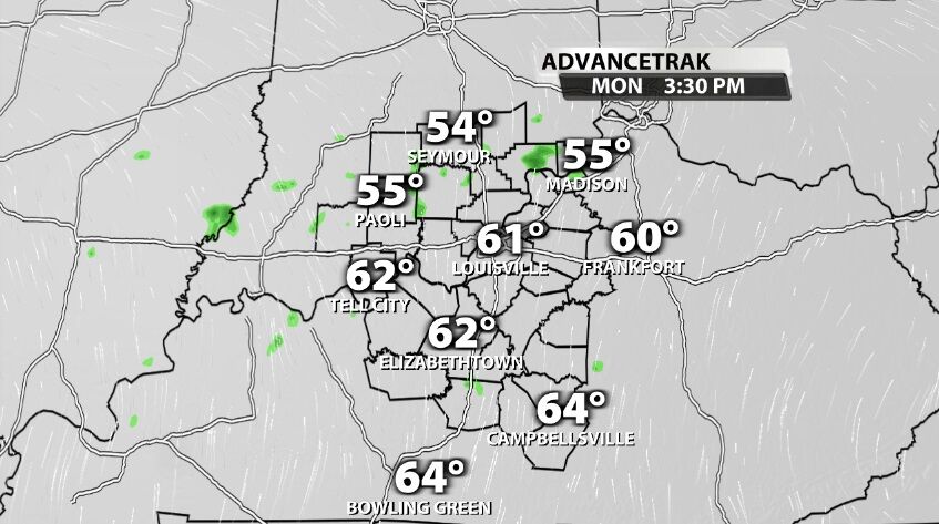
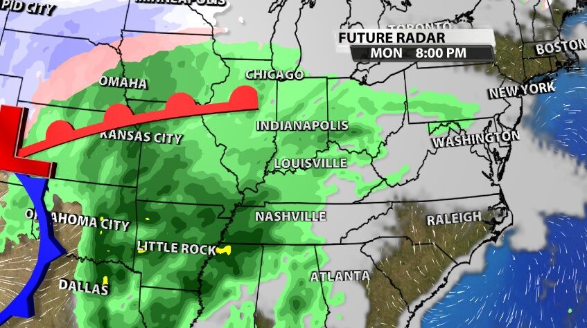
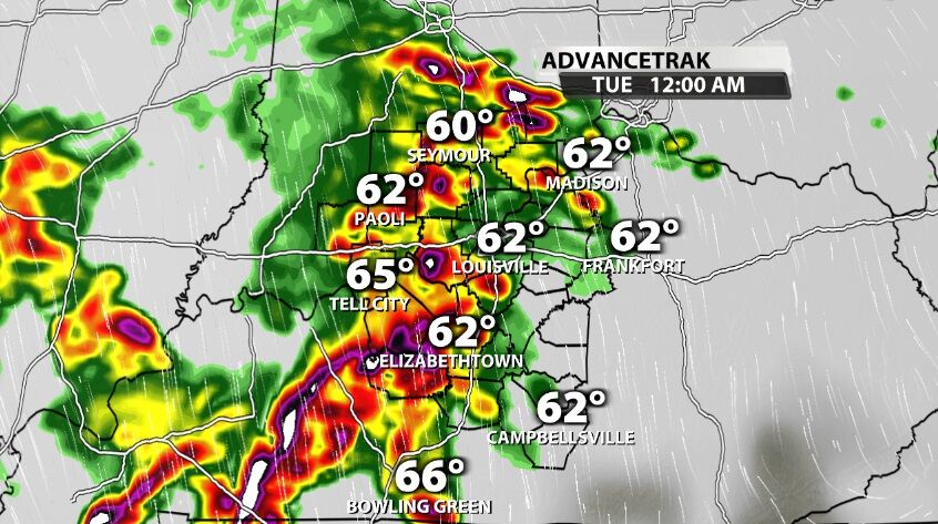
Light rain starts earlier Monday, but the heavier rain and thunderstorms wait until after dark. This first round of storms is likely to be elevated, meaning the energy is a little displaced. Small hail, heavy rain, thunder and lightning, and gusty wind are the expected threats as these storms grow late Monday night.
There looks to be a lull in activity around Tuesday afternoon. If we are still holding on to temperatures in the 60s, and if the clouds break at all, we could build up enough instability to make the next round more active than the first.
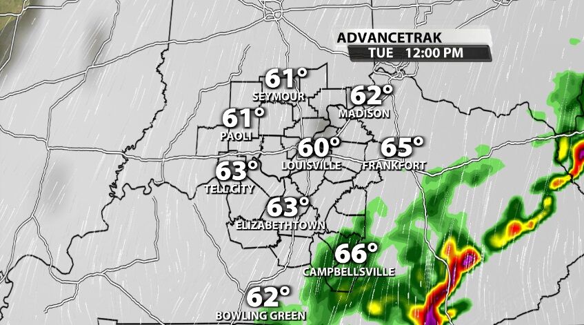
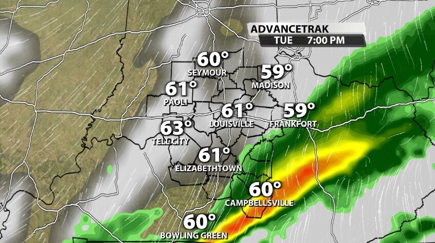
That next round comes in Tuesday evening, and the strength of these storms will depend entirely on what happens earlier in the day Tuesday. At this point plan for another round of heavy rain, gusty wind, and thunder and lightning. We will update you on TV and on wdrb.com during the day Tuesday, so you have a better idea of what to expect.
It is possible to see one last round of storms develop along the cold front as it moves through our area early Wednesday morning. The front may provide enough lift to generate a few more storms before moving out of our area.
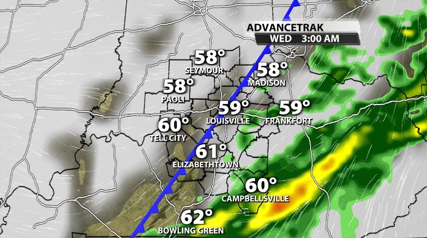
By late morning or early afternoon Wednesday, the cold front will be east of us, having moved out of our area.
SUMMARY
Rounds of storms with heavy rain will move through our area Monday night through early Wednesday morning. Severe weather warnings are not a guarantee, but they are possible. Strong wind gusts are a main concern, so take time during the day Monday to secure loose, light objects outdoors around your home.
We will go through the timing in much more detail on WDRB News tonight and 10 and during the day Monday so you can see when the heaviest rain and strongest storms move into your community. You can find all our meteorologists on social media if you still have questions about this setup that need to be answered.


