
A Louisville park just got some big upgrades.
From
To

About three months ago, an EF-2 tornado touched down in Prospect, Kentucky.

Top Story
Tornadoes and strong winds rocked the Kentuckiana area Tuesday evening, leaving scattered sheds, furniture, and other debris across the area.

The National Weather Service has issued a Wind Advisory for our area Monday night through Tuesday evening when wind gusts may go as high as 45 mph. That is strong enough to toss around loose objects, so bring those indoors or secure things you plan to leave outside.

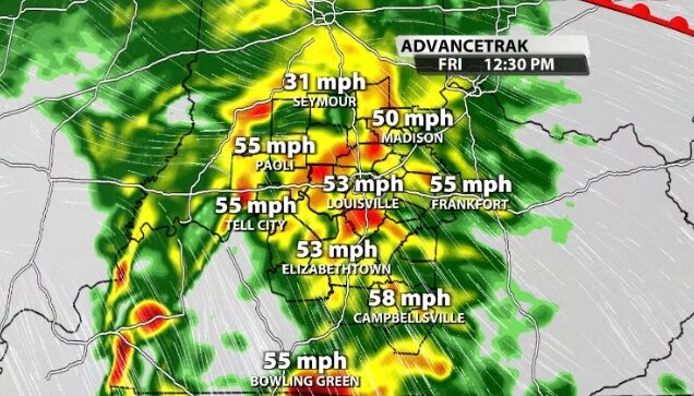
Our area will experience strong, potentially damaging wind gusts Friday. Our northern communities are under a High Wind Watch and the rest of our area is included in a Wind Advisory through the day Friday and into Saturday morning.

Top Story
National Weather Service Survey Teams have spent two days examining damage from the storm.

The Storm Prediction Center has issued a Severe Thunderstorm Watch for most of our area Saturday until 11 PM.
Severe storms are moving through our area this morning and rounds of strong storms will plague our area for the next few days.

We just finished a conference call with the National Weather Service to their local partners to discuss more about the threat of severe storms tonight. Here's a summary of what we talked about in that call: