Our area will experience strong, potentially damaging wind gusts Friday. Our northern communities are under a High Wind Watch and the rest of our area is included in a Wind Advisory through the day Friday and into Saturday morning.
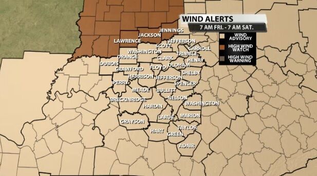
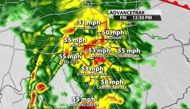
Both the Watch and Advisory are in place to alert you that wind gusts over 50 mph will be possible Friday and are strong enough to do damage.
Below is the text from the Wind Advisory that affects most of our area:
...WIND ADVISORY IN EFFECT FROM 7 AM EST /6 AM CST/ FRIDAY TO
7 AM EST /6 AM CST/ SATURDAY...
* WHAT...Southwest winds 20 to 30 mph with gusts 45 to 55 mph
expected.
* WHERE...Portions of southern Indiana and central Kentucky.
* WHEN...From 7 AM EST /6 AM CST/ Friday to 7 AM EST /6 AM CST/
Saturday.
* IMPACTS...Gusty winds could blow around unsecured objects. Tree
limbs could be blown down and power outages may result.
* ADDITIONAL DETAILS...It is possible that portions of this wind
advisory may be upgraded to a high wind warning if the threat
for damaging wind gusts increases. Stay up to date with the
latest forecasts.
PRECAUTIONARY/PREPAREDNESS ACTIONS...
Use extra caution when driving, especially if operating a high
profile vehicle. Secure outdoor objects.
Here is the text from the High Wind Watch which alerts you to stronger wind potential in our far northern communities:
...HIGH WIND WATCH IN EFFECT FROM FRIDAY AFTERNOON THROUGH
SATURDAY AFTERNOON...
* WHAT...Southwest winds 25 to 35 mph with gusts up to 60 mph
possible.
* WHERE...Portions of central, east central, north central,
south central, southeast, southwest and west central Indiana.
* WHEN...From Friday afternoon through Saturday afternoon.
* IMPACTS...Damaging winds could blow down trees and power lines.
Power outages are possible. Travel could be difficult,
especially for high profile vehicles.
PRECAUTIONARY/PREPAREDNESS ACTIONS...
Monitor the latest forecasts and warnings for updates on this
situation. Fasten loose objects or shelter objects in a safe
location prior to the onset of winds.


