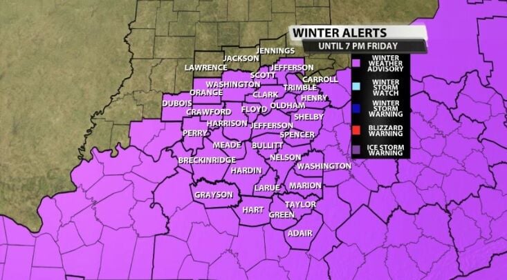
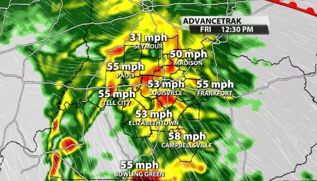
The National Weather Service has issued a Wind Advisory for our area Monday night through Tuesday evening when wind gusts may go as high as 45 mph. That is strong enough to toss around loose objects, so bring those indoors or secure things you plan to leave outside.
A La Niña Watch has been issued as climate scientists see evidence for a coming flip from El Niño to La Niña.
A Winter Weather Advisory has been issued for part of our area Monday night through Tuesday morning. This Advisory is highlighting which spots could see accumulating snow in that time frame.
Dense Fog Advisory issued for our area Wednesday night through Thursday morning when fog may be dense enough to create low visibility leading to hazardous driving conditions.
A wintry mix of freezing rain and snow is moving our direction from the southwest. This mix will move into our area this afternoon, and we will see snow spread across more of the area tonight.
The Winter Weather Advisory has been expanded to include more of our area and a Winter Storm Warning comes right up to the edge of our coverage area.
Our area will experience strong, potentially damaging wind gusts Friday. Our northern communities are under a High Wind Watch and the rest of our area is included in a Wind Advisory through the day Friday and into Saturday morning.
The National Weather Service in Louisville has issued a Winter Weather Advisory ahead of snow showers moving into our area Monday.
The National Weather Service in Louisville issued a Frost Advisory in our southeastern communities for Sunday morning.
Hardinsburg City Clerk David Bollinger said Thursday that the city started noticing issues in its storage tanks late Tuesday.