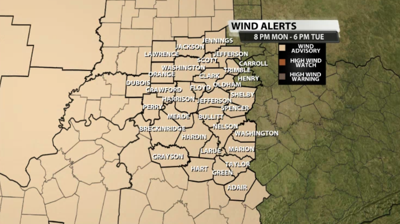

The National Weather Service has issued a Wind Advisory for our area Monday night through Tuesday evening when wind gusts may go as high as 45 mph. That is strong enough to toss around loose objects, so bring those indoors or secure things you plan to leave outside.

Below is the text issued by NWS Louisville with the Advisory:
...WIND ADVISORY IN EFFECT FROM 8 PM EDT /7 PM CDT/ MONDAY TO
6 PM EDT /5 PM CDT/ TUESDAY...

* WHAT...South winds 20 to 30 mph with gusts up to 45 mph
  expected.

* WHERE...Portions of southern Indiana and central Kentucky.

* WHEN...From 8 PM EDT /7 PM CDT/ Monday to 6 PM EDT /5 PM CDT/
  Tuesday.

* IMPACTS...Gusty winds could blow around unsecured objects.
  Tree limbs could be blown down and a few power outages may
  result.

* ADDITIONAL DETAILS...The most likely timing and location of the
  strongest winds appears to be Monday night west of Interstate 65.

PRECAUTIONARY/PREPAREDNESS ACTIONS...

Use extra caution when driving, especially if operating a high
profile vehicle on north south roads such as Interstates 65 and
165. Secure outdoor objects.


