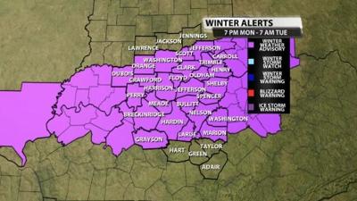

A Winter Weather Advisory has been issued for part of our area Monday night through Tuesday morning. This Advisory is highlighting which spots could see accumulating snow in that time frame.

Tune into WDRB News tonight at 10 to hear more about the forecast including how much snow we are expecting in these spots and how snow is possible while we are see temperatures so far above freezing.
Below is the text issued with the Advisory:
...WINTER WEATHER ADVISORY IN EFFECT FROM 7 PM EST /6 PM CST/
MONDAY TO 7 AM EST /6 AM CST/ TUESDAY...
* WHAT...Rain is expected to quickly change over to wet snow
Monday evening. The snow could be heavy at times and
accumulations of up to 4 inches in some locations is possible.
* WHERE...Portions of and south central Indiana and east
central, north central, northwest and south central Kentucky.
* WHEN...From 7 PM EST /6 PM CST/ Monday to 7 AM EST /6 AM CST/
Tuesday.
* IMPACTS...Plan on slippery road conditions. The hazardous
conditions could impact the Tuesday morning commute.
* ADDITIONAL DETAILS...It is likely that a narrow band of heavy
snow will develop with this system. At this time, it is
impossible to determine where this band may set up. This
advisory highlights the areas of southern Indiana and central
Kentucky at most risk for impactful snow and subsequent changes
in the forecast may be required. Stay tuned for future forecast
updates.
PRECAUTIONARY/PREPAREDNESS ACTIONS...
Slow down and use caution while traveling.
In Indiana, for Indiana Road Conditions please visit
http://pws.trafficwise.org In Kentucky, for Kentucky Road
Conditions please visit http://goky.ky.gov


