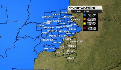
The Storm Prediction Center has issued a Severe Thunderstorm Watch for most of our area Saturday until 11 PM. Storms are popping up west of us with strong wind gusts and hail, and they will move toward our area through the evening. An isolated tornado also cannot be ruled out with these storms.

Below is the text issued with the Watch by the Storm Prediction Center:
The NWS Storm Prediction Center has issued a

   * Severe Thunderstorm Watch for portions of
     Southern Illinois
     Central and southern Indiana
     North-central Kentucky

   * Effective this Saturday afternoon and evening from 455 PM until
     1100 PM EDT.

   * Primary threats include...
     Scattered damaging winds likely with isolated significant gusts
       to 75 mph possible
     Isolated large hail events to 1.5 inches in diameter possible
     A tornado or two possible

   SUMMARY...Developing MCS over the Mid-Mississippi Valley will spread
   east-northeast across the Wabash and Lower Ohio Valley. Damaging
   winds should be the main threat.


