A strong low pressure center will barrel through our area this weekend bringing an active pattern that takes us from thunderstorms to snow potential. This post discusses what we are watching and what you may see from the weather this weekend.

The Storm Prediction Center has issued a Severe Thunderstorm Watch for most of our area Saturday until 11 PM.

The Storm Prediction Center has issued a Severe Thunderstorm Watch for part of our area until 10 PM Central (11 PM Eastern).
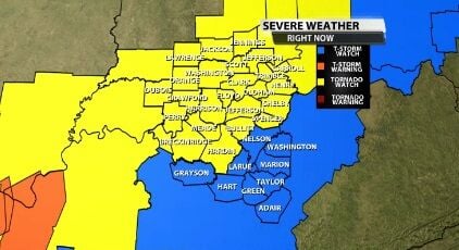
A new Severe Thunderstorm Watch has been issued for the parts of our area not covered by the Tornado Watch.

A few of our northeastern communities have been included in a Severe Thunderstorm Watch until 7 PM. The main threat is strong, damaging wind gusts inside thunderstorms with small hail. Larger hail and isolated tornadoes cannot be ruled out but are less of a threat in our area.

The Storm Prediction Center and National Weather Service have issued a Severe Thunderstorm Watch for most of our area until 1 PM.

The Storm Prediction Center has issued a Severe Thunderstorm Watch for many of our northern communities until 11 PM Central/Midnight Eastern.

The Storm Prediction Center and National Weather Service have expanded the Severe Thunderstorm Watch to include more of our WDRB communities. This will remain in effect until 7 PM.

A Severe Thunderstorm Watch has been issued for part of our area Wednesday until 8 PM Eastern.

The Severe Thunderstorm Watch has been expanded to include more of our WDRB communities now that we see what these storms can do. The Watch goes until Noon Eastern.