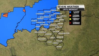
The Storm Prediction Center has issued a Severe Thunderstorm Watch for many of our northern communities until 11 PM Central/Midnight Eastern.

Strong wind gusts in thunderstorms are the main threat tonight. Small hail, frequent lightning, and heavy rain also look likely. Tune into WDRB News tonight at 10 to see where the storms are and how strong they become. Below is the text issued with the Watch by the SPC:
  * Effective this Sunday afternoon and evening from 530 PM until
     1100 PM CDT.

   * Primary threats include...
     Scattered damaging wind gusts to 70 mph possible
     Isolated large hail events to 1 inch in diameter possible

   SUMMARY...A line of thunderstorms is intensifying from southeast
   Missouri into southern Indiana.  This activity will build southward
   this afternoon and evening, posing a risk of locally damaging wind
   gusts.

   The severe thunderstorm watch area is approximately along and 45
   statute miles north and south of a line from 50 miles southwest of
   Farmington MO to 70 miles east of Bloomington IN. For a complete
   depiction of the watch see the associated watch outline update
   (WOUS64 KWNS WOU9).

   PRECAUTIONARY/PREPAREDNESS ACTIONS...

   REMEMBER...A Severe Thunderstorm Watch means conditions are
   favorable for severe thunderstorms in and close to the watch area.
   Persons in these areas should be on the lookout for threatening
   weather conditions and listen for later statements and possible
   warnings. Severe thunderstorms can and occasionally do produce
   tornadoes.


