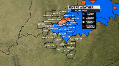

A Severe Thunderstorm Watch has been issued for part of our area Wednesday until 8 PM Eastern. The counties shaded in blue are covered by the Watch, and those are the places the strongest storms are most likely to pop up this afternoon.

Storms are already producing severe-strength wind and hail. Wind gusts up to 60 mph and hail up to one inch in diameter will be possible in storms tonight with some of those growing even stronger. Below is the text issued by the Storm Prediction Center with this Watch:
The NWS Storm Prediction Center has issued a

   * Severe Thunderstorm Watch for portions of
     Far southeast Indiana
     Northern Kentucky
     Southwest Ohio

   * Effective this Wednesday afternoon and evening from 355 PM
     until 800 PM EDT.

   * Primary threats include...
     Scattered damaging wind gusts to 65 mph possible

   SUMMARY...A multicell cluster will likely evolve eastward across the
   middle Ohio Valley with a threat for damaging winds.

   The severe thunderstorm watch area is approximately along and 45
   statute miles north and south of a line from 50 miles west northwest
   of Lexington KY to 85 miles east of Cincinnati OH. For a complete
   depiction of the watch see the associated watch outline update
   (WOUS64 KWNS WOU3).

   PRECAUTIONARY/PREPAREDNESS ACTIONS...

   REMEMBER...A Severe Thunderstorm Watch means conditions are
   favorable for severe thunderstorms in and close to the watch area.
   Persons in these areas should be on the lookout for threatening
   weather conditions and listen for later statements and possible
   warnings. Severe thunderstorms can and occasionally do produce
   tornadoes.


