
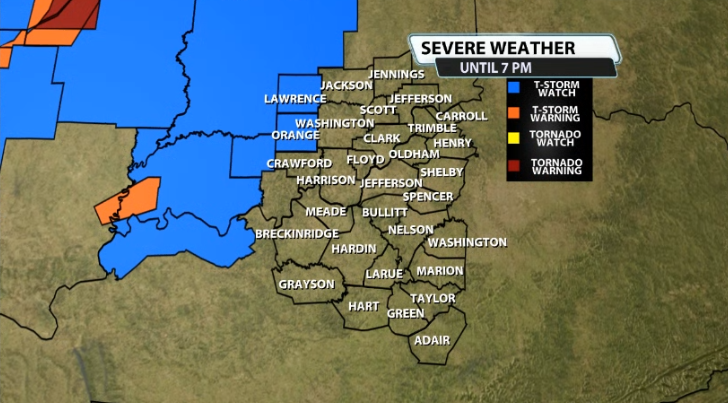
The first watch for our area for today's/tonight's severe threat has been posted for our area. This watch is not for storms later tonight, but for storms ahead of the main line that could be on the stronger side before that main line arrives. Lawrence and Orange counties are the only counties included in this first watch of the day. It is in effect until 7PM. We will likely have another watch later this evening/tonight.
Here's more information on the watch from the SPC:
* Severe Thunderstorm Watch for portions of
Southeast Illinois
Southern and Central Indiana
Northern Kentucky
* Effective this Monday morning and evening from 1110 AM until
600 PM CDT.
* Primary threats include...
Scattered damaging wind gusts to 70 mph possible
Scattered large hail events to 1.5 inches in diameter possible
A tornado or two possible
SUMMARY...Elevated storms will spread generally eastward and
potentially pose a hail risk while damaging wind risk may increase
into western/southern Indiana as well as an upstream linear cluster
of storms moves into the region.
The severe thunderstorm watch area is approximately along and 35
statute miles east and west of a line from 15 miles east of
Lafayette IN to 20 miles west southwest of Owensboro KY. For a
complete depiction of the watch see the associated watch outline
update (WOUS64 KWNS WOU9).
PRECAUTIONARY/PREPAREDNESS ACTIONS...
REMEMBER...A Severe Thunderstorm Watch means conditions are
favorable for severe thunderstorms in and close to the watch area.
Persons in these areas should be on the lookout for threatening
weather conditions and listen for later statements and possible
warnings. Severe thunderstorms can and occasionally do produce
tornadoes.
As mentioned we will see the main line of storms arrive after around 7-8PM and into the overnight hours later tonight. This watch is for the first wave of storms before that main one arrives later.


