We may see a few flurries flying Monday morning, but this is not the snow chance to get excited about.
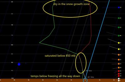
This flurry chance comes solely from a saturated low level of the atmosphere. Normally snowflakes develop inside the cloud in the middle levels of the atmosphere which I've labeled below as the snow growth region. Monday morning, though, the middle and upper levels of the atmosphere (in the layer of the atmosphere where we watch for weather) are dry. We know that because the green and red lines are so far away from each other. The red line is the temperature of the air at that height and the green line is the dewpoint, representing moisture in the air. The farther apart those lines are, the drier the air is. With air that dry, snowflakes will not form.

As we look at the lower level of the atmosphere, though, the red and green lines are right next to each other. That means the air is full of moisture here, a.k.a. saturated. Since snow won't form in the snow growth region, we won't get big snowflakes or heavy snow. But since the lower levels are saturated and colder than freezing, we can form the snow equivalent of drizzle.
The diagonal light blue line is the line representing freezing (0ºC) in the atmosphere. Anytime the red temperature line is to the left of the line I've highlighted in blue, it means the air there is colder than freezing. Anytime the red line is to the right of the light blue one, the air is warmer than freezing, which is not the case anywhere in the atmosphere in this example.
So the snow we see Monday morning would be the equivalent of drizzle instead of rain. Don't expect big snowflakes that stick and accumulate. Expect the drizzle version of snow - a few small flakes hitting your windshield on your morning drive.


