

The NWS has completed their preliminary survey of one of the reported tornado paths in our area from Sunday night's storm system.
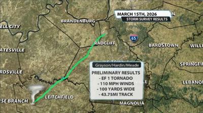
In their preliminary findings, the NWS found EF-1 tornado damage with max winds around 110mph. The max width of the tornado was 100 yards. The NWS also stated in their preliminary report that this tornado was on the ground for 43.75 miles.

I (Bryce), put the length in bold and italics because of the questions that should obviously come up when talking about a weaker-end tornado reportedly being on the ground for that long.
We do have questions about whether this was a continuous path or not as this is an unusually long path for a very narrow EF-1 tornado.
This path is still preliminary for right now and the NWS-Louisville will be reassessing over the coming week if the path was truly continuous. We will update you as that confirmation and reassessment takes place. This tornado didn't cause EF-1 damage the entire path it took, as that's the case for most tornadoes, but the NWS will work on finding aerial sources to confirm the track length.
Below is the survey summary published by the National Weather Service in Louisville. It discusses in detail many of the damage markers NWS staff look for to determine how strong the wind was and thus, what EF ranking the tornado was. Be advised, this does discuss the fatality of farm animals:
The first report of the tornado came from Caneyville Fire
Department of a tornado touchdown observed north of Caneyville.
Damage was observed north of Caneyville with tree damage near
Highway 79 to near Chronicle Lee Road. The tornado continued
along Hopewell Road in Grayson County near the Caneyville and
Millwood areas. Several farm outbuildings had the roof peeled
off, with one farm having wood planks from the barn damage
thrusted into the nearby residence. The residence also had
shingle damage. Max winds of 100 mph were estimated in this
location.
The tornado continued to the northeast across Jones Hill
and highway 54 to Stones Chapel Road. Several farm outbuildings
and tree damage was observed, including roof material lofted into
nearby trees. The tornado continued across Clifty Church Drive
where a farm had damage to several outbuildings where rooftops
were destroyed. At this location, 3 head of cattle were fatally
injured resulting in roughly $7K in damages. Debris from the
farm was lofted into the treeline about a tenth of a mile from
the property.
The tornado continued to the northeast toward Lilac where several
farm outbuildings on a hill top were completely destroyed. Wood
planks were driven into the ground in several directions and
debris was lofted over the nearby hill. Significant tree damage
was observed here as well. Max estimated wind speeds of 110 mph
were observed here.
The tornado continued to the northeast toward Brandenburg road
where trees were uprooted. The tornado continued across Rough
River Lake and into Hardin county near Hardin Springs where
several trees were uprooted and snapped. The tornado continued to
the northeast near Pierce Mill and Garfield. Significant damage
occurred to a home near Pierce Mill Road, where a portion of the
roof was taken from the home above the garage and living space
below. Mud splatter occurred to the front of the home at this
location, and a wood plank was thrown backward into the roof above
the living room. Several wood pieces were impaled into the ground
at the property. The tornado continued near Vertrees and toward
Four Corners in Hardin County, where outbuilding damage was
observed and several trees in a tree line were snapped. Max winds
were estimated to be near 100 mph at this location.
The tornado continued towards Berrytown Road where several
locations had significant tree and farm outbuilding damage.
Several barns lost their roofs with wood plank impalements nearby.
Winds were estimated to be around 110 mph at this location. The
tornado continued across Rineyville road and Joe Prather Highway
near Flaherty. The Meade County Bank had sign damage and some
minor roof damage. Damage was observed to trees and some houses
along Camelot Drive and Rolling Hills Road. The tornado continued
across fields and did extensive damage to a farm beside Fort
Avenue. Multiple farm buildings were significantly damaged with
roofs lofted across Fort Avenue into a field.
The tornado continued across Highway 31 onto Fort Knox where an
advanced spotter reported damage to trees on base. Up to that
point, the storm had been taking a hard left to the rest of the
storm motion, and this last damage point was more in line with
storm motion. Beyond this point, there was no observable or
reported damage.


