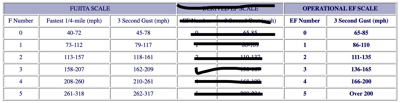

A tornado touched down May 1st on the island of Puerto Rico which is pretty unusual. After surveying the damage, the National Weather Service office there determined this was an EF-1 tornado making this even more unusual. The estimated peak wind in this tornado was 107 mph making this a strong EF-1. EF-2 starts at 111 mph (see the scale at the bottom of the page).
Arecibo tornado event May 1st, 2022. #prwx pic.twitter.com/J9FObNAVsr
— NWS San Juan (@NWSSanJuan) May 2, 2022
The information from the NWS says at its widest this tornado was one tenth of a mile wide and was on the ground for about five minutes during which it traveled a little over a third of a mile. Thankfully there were no injuries or deaths from this tornado. The Industrial Park in Arecibo sustained the most damage; the NWS survey includes this note: "One warehouse suffered major damage including partial loss of the roof. This resulted in significant interior damage to the warehouse. Numerous trees were snapped as well as power poles along the tornado track." A separate note in that survey also mentions damage to traffic signs near a hospital. Click on the tweet above to see a summary of that report from the National Weather Service and a map of the tornado track.
We see tornadoes stronger than this in Kentuckiana, but tornadoes are unusual in Puerto Rico. This tornado from earlier in the week is only the 22nd tornado to touch down on the island since 1950 when this record-keeping started, and it's the first one in nearly three years (since September 30, 2019). 20 of those 22 tornadoes have been EF-0; the only other tornado stronger than EF-0 was an F-1 tornado that touched down August 30, 1974. That means it's been almost 48 years since the island has seen a tornado as strong as the one that touched down a few days ago. The reason for the difference between the F-1 and EF-1 tornadoes is that Dr. Fujita developed the F-scale in 1971 which was updated/replaced in 2007 by the Enhanced F-scale (the EF-scale we still use). The graphic below shows the difference in windspeed between the two scales.


