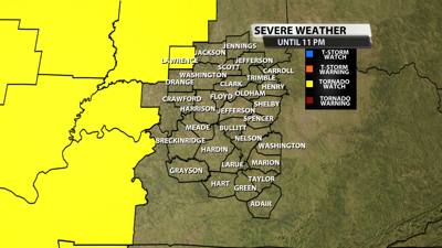

While this watch only covers a small portion of our area, watches will be expanded in the coming hours so stay with WDRB for continuing severe weather coverage.
The NWS Storm Prediction Center has issued a
* Tornado Watch for portions of
Central and Eastern Illinois
Western and Central Indiana
* Effective this Wednesday afternoon and evening from 315 PM
until 1000 PM CDT.
* Primary threats include...
Several tornadoes likely with a couple intense tornadoes
possible
Widespread damaging winds likely with isolated significant gusts
to 80 mph possible
Scattered large hail events to 1.5 inches in diameter possible

SUMMARY...Severe storms are expected to develop and increase
initially across central/northeast Illinois late this afternoon, and
steadily progress east-northeastward into eastern Illinois and much
of western/central/northern Indiana by evening.
The tornado watch area is approximately along and 90 statute miles
north and south of a line from 30 miles west northwest of Decatur IL
to 45 miles north northeast of Indianapolis IN. For a complete
depiction of the watch see the associated watch outline update
(WOUS64 KWNS WOU9).
PRECAUTIONARY/PREPAREDNESS ACTIONS...
REMEMBER...A Tornado Watch means conditions are favorable for
tornadoes and severe thunderstorms in and close to the watch
area. Persons in these areas should be on the lookout for
threatening weather conditions and listen for later statements
and possible warnings.