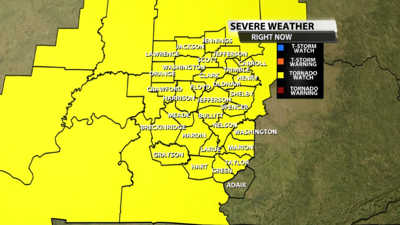

The Storm Prediction Center has issued a Tornado Watch until 10 am for a chunk of our area tonight. Remember, it is important to stay weather aware and have a way to get warnings tonight.

URGENT - IMMEDIATE BROADCAST REQUESTED
Tornado Watch Number 41
NWS Storm Prediction Center Norman OK
235 AM EDT Sat Mar 15 2025
The NWS Storm Prediction Center has issued a
* Tornado Watch for portions of
Central and Southern Indiana
Central Kentucky
Western Ohio
* Effective this Saturday morning from 235 AM until 1000 AM EDT.
* Primary threats include...
A couple tornadoes possible
Scattered damaging winds and isolated significant gusts to 75
mph likely
Isolated large hail events to 1 inch in diameter possible
SUMMARY...A broken band of thunderstorms with embedded supercells
and bowing segments will move east across the Watch area during the
overnight into the early morning. Damaging gusts and tornadoes will
be the primary hazards with the stronger storms.
The tornado watch area is approximately along and 60 statute miles
east and west of a line from 10 miles east northeast of Muncie IN to
25 miles southeast of Bowling Green KY. For a complete depiction of
the watch see the associated watch outline update (WOUS64 KWNS
WOU1).
PRECAUTIONARY/PREPAREDNESS ACTIONS...
REMEMBER...A Tornado Watch means conditions are favorable for
tornadoes and severe thunderstorms in and close to the watch
area. Persons in these areas should be on the lookout for
threatening weather conditions and listen for later statements
and possible warnings.