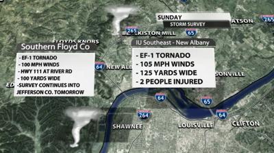
The National Weather Service found two EF-1 tornadoes touched down Sunday morning in Floyd County, Indiana. The first was on the IU Southeast campus in New Albany. Below is the text the National Weather Service issued to discuss what they found there:
NWS STORM SURVEY CONFIRMED AN EF-1 TORNADO
TOUCHED DOWN NEAR THE NATURAL SCIENCE AND
NURSING BUILDING ON THE CAMPUS OF INDIANA
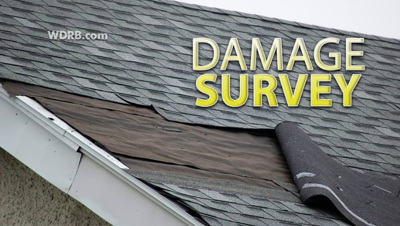
UNIVERSITY SOUTHEAST. THERE WAS ROOF AND
SIDING DAMAGE TO THE BUILDING AND TREES
BETWEEN THE PARKING LOT AND GRENADIER DRIVE,
FACING EAST, NORTH, AND NORTHWEST. POWER
POLES WERE SNAPPED ALONG HIGHWAY 111 (GRANT
LINE RD). APARTMENTS ALONG COUNTRYSIDE DRIVE
HAD SHINGLE, GUTTER AND DOWNSPOUT DAMAGE.
HOWEVER, ONE OF THE APARTMENTS HAD A LARGE
SECTION OF ITS ROOF TORN OFF WITH DEBRIS
BEING THROWN IN ALL DIRECTIONS. TWO PEOPLE
IN THE APARTMENT BUILDING WERE INJURED WITH
HEAD LACERATIONS. SHINGLES WERE THROWN
SEVERAL HUNDRED YARDS. TREES WERE UPROOTED,
SNAPPED AND TWISTED ALONG COUNTRYSIDE DR AND
MELVYN DRIVE. TREES WERE FACING FROM THE
NORTHWEST TO THE SOUTHEASTERLY DIRECTION.
WIND SPEEDS IN THIS AREA WERE 100 MPH WITH A
WIDTH OF 125 YARDS. ONE HOUSE ON MELVYN
DRIVE HAD NO DAMAGE EXCEPT FOR A PIECE OF
GUTTER THAT WAS THROWN AS A MISSILE IN A
NORTHERLY DIRECTION THROUGH A WINDOW INTO
THEIR LIVING ROOM. ONE OUTBUILDING WAS
THROWN TO THE SOUTH, WHILE ANOTHER
OUTBUILDING WAS THROWN TO THE NORTH, THREE
HOUSES APART. POWERLINES WERE SNAPPED, AND
ONE LARGE PIECE OF ROOFING MATERIAL FROM THE
APARTMENT WAS IMPALED INTO THE GROUND. THERE
WAS NUMEROUS WOODEN AND METAL FENCE DAMAGE
BETWEEN MELVYN DR AND PRESWICK SQUARE. A
VERY BIG HEALTHY OAK TREE WAS UPROOTED AND
WAS FACING EAST NORTHEASTERLY DIRECTION.
WIND DAMAGE IN THIS AREA WAS EF1, 105 MILES
PER HOUR WITH A WIDTH OF 100 YARDS. There was a second EF-1 tornado in southern Floyd County, but that survey will be continued Monday to see if the tornado touched down again across the river in Jefferson county. So far NWS employees found evidence of wind up to 100 mph and a maximum width of 100 yards. They described quite a lot of damage around The Sporting Club at the Farm on Highway 111.

The National Weather Service also went to the Shelbyville area where more damage was reported after these storms and found straight-line wind damage occurred there, not a tornado. We will update you Monday as we learn more from the National Weather Service.


