

LOUISVILLE, Ky. (WDRB) -- A new study ranks the 53 most dangerous stretches of roadway in Louisville, and one of the city's most-traveled thoroughfares took two of the top three spots.
The study, a joint effort by Louisville Metro Government and the Kentucky Transportation Cabinet and prepared by Palmer Engineering, is called Vision Zero Louisville. It included data for all public streets and roadways in Jefferson County except for Interstates 64, 71, 264 and 265. Every crash was logged from Jan. 1, 2018, to Dec. 31, 2022, only excluding those that occurred in parking lots, which made up just 5.3% of those reported county-wide, the study said.
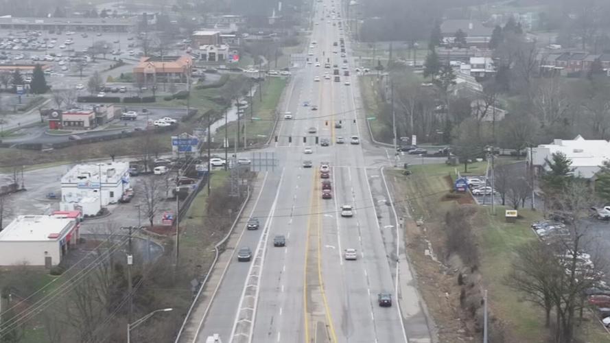
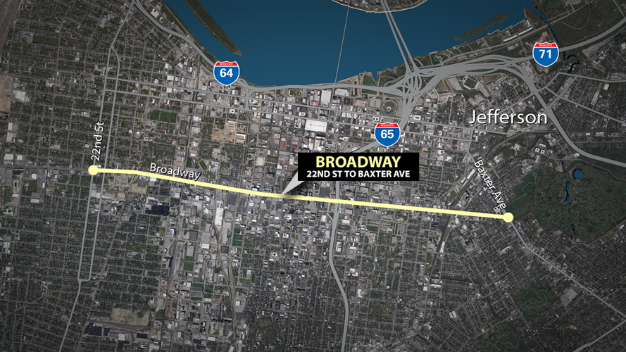
The most dangerous stretch of road in Jefferson County, the study showed, was Broadway from 22nd Street to Baxter Avenue. The third-most dangerous stretch was Broadway from from 22nd Street to 35th Street.

The most dangerous stretch of road in Jefferson County, the study showed, was Broadway from 22nd Street to Baxter Avenue. (WDRB Graphic)
Chris Glasser, the president of Streets for People, a Louisville nonprofit dedicated to improving the safety of the city's streets, said Broadway's six or seven driving lanes and heavy pedestrian traffic in the area make for a "very unsafe environment."
"Those wider roads encourage speeding and encourage, sort of, reckless driving," Glasser said. "That can be dangerous for people in the cars (and) pedestrians on the roadways."
Glasser praised the city for its efforts to transform the corridor, mainly the "Broadway Master Plan," which the "American Society of Highway Engineer National Scanner Magazine" featured as a way to "enhance quality of life, economic vitality, safety, sustainability and equity for Louisville."
"The city, to their credit, has identified Broadway as an important project," Glasser said. "... They've pursued federal funding to make those changes happen. And, ultimately, they need the support of KYTC to make those changes go through."
The routes were ranked based upon what the study called "Equivalent Property Damage Only," a value assigned to each crash based on its severity — as determined by the Kentucky Transportation Cabinet — and its cost, an adjusted number that utilizes Federal Highway Administration figures and is then adjusted for inflation.
Seventeen of the 20 most dangerous stretches of roadway in Jefferson County are owned by the Kentucky Transportation Cabinet. Of the 53 "High Injury Network" routes ranked by the study, 85% of the 152.5 miles of roadway are state-owned.
"It's great that Metro is highlighting the safety issues on these roads," said Chris Glasser, president of Streets for People, a Louisville nonprofit dedicated to improving the safety of the city's streets. "And I think it brings to light that we really need buy-in from the state to make these roads safer. Because they're the ones, ultimately, who are going to be able to fix the problem."
Other corridors of concern include South 7th Street between Algonquin Parkway and South 9th Street as well as Bardstown Road between Captain Place and Beulah Church Road.
"Louisville is a Vision Zero city, with a vision of zero roadway deaths on surface streets by 2050," Claire Yates, who manages the Vision Zero program, said in a written statement Wednesday. "A High Injury Network is a data-driven approach which identifies non-interstate roadway segments that account for a disproportionate amount of a community's fatal and serious injury crashes. Developing a High Injury Network is a national best practice among Vision Zero communities. The High Injury Network not only identifies where fatal and serious injury crashes are more likely to occur but will also allow Louisville Metro Public Works and the Kentucky Transportation Cabinet to focus limited resources on improving safety along the most dangerous corridors in Louisville."
The study features a graph showing all non-interstate crashes, county-wide, fell by more than half from 2019 to 2020 and stayed down through 2022. But those figures are a result of the Louisville Metro Police Department's change in policy, an effort to minimize exposure with the public during the height of the COVID-19 pandemic. Officers began only responding to fatal and injury crashes. So while reported crashes fell drastically, traffic fatalities actually rose by 9% in both 2021 and 2022.
"It's a public asset. It's a shared community space," Glasser said. "Making it not just for moving cars but for quality of life is an important thing that I think is sometimes overlooked."
KYTC said in a written statement Wednesday that Vision Zero still be used to "prioritize future safety improvements."
"The Louisville High Injury Network (HIN) is a collaborative effort between Louisville Metro/Vision Zero and Kentucky Transportation Cabinet staff to support the Vision Zero goal of eliminating roadway fatalities for a safer Kentucky," KYTC said. "The development of the HIN evaluated non-interstate routes in Jefferson County to identify opportunities to enhance highway safety for all Louisville Metro/Jefferson County roadway users where serious injury or fatal crashes are prevalent. This initiative is a national best practice and is a helpful tool Louisville Metro and KYTC can use to identify and prioritize future safety improvements with available funding."
Copyright 2024 WDRB Media. All Rights Reserved.


