The National Weather Service has issued a Red Flag Warning for most of our area this afternoon and a Fire Weather Watch for the area on Friday. There are three different "weather alerts" related to fire danger in effect in our area right now, and all three have completely different names. Let's start by defining what each of these means and how it impacts you:
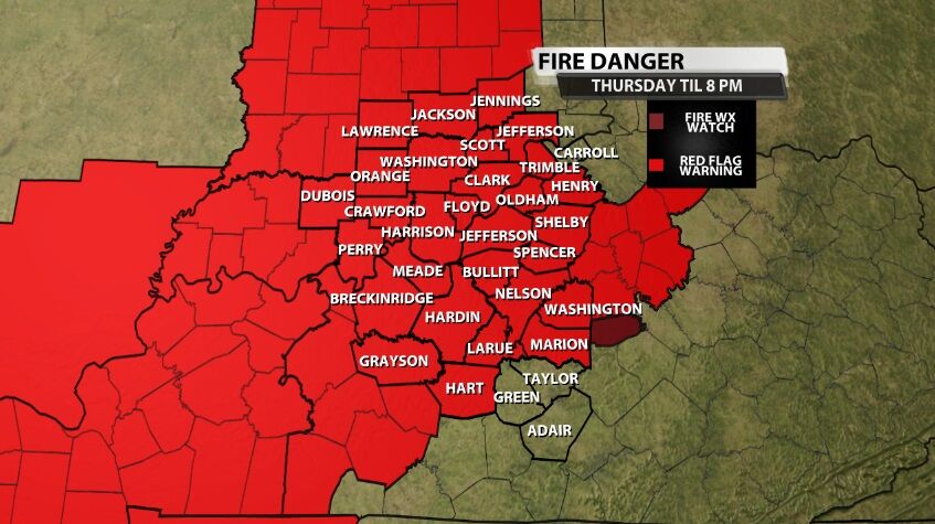
Red Flag Warning (above): Any time we say the word "warning," the weather is hazardous enough to warrant a change in your behavior. In this case conditions are right for wildfires to be able to grow and spread quickly, so avoid outdoor burning. This was issued because the wind will be blowing from the west 15-20 mph consistently this afternoon with gusts up to 35 mph. The air also has 20%-25% relative humidity meaning, not only is the ground dry, but the air is also very dry. The text below is from the National Weather Service office in Louisville which issued this alert:
A RED FLAG WARNING MEANS THAT CRITICAL FIRE WEATHER CONDITIONS
ARE EITHER OCCURRING NOW....OR WILL SHORTLY. A COMBINATION OF
STRONG WINDS...LOW RELATIVE HUMIDITY...AND WARM TEMPERATURES CAN
CONTRIBUTE TO EXTREME FIRE BEHAVIOR.

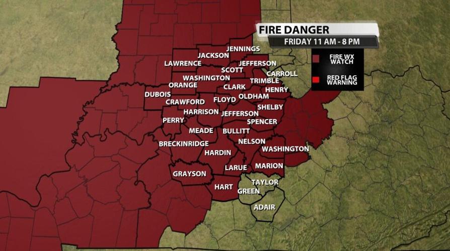
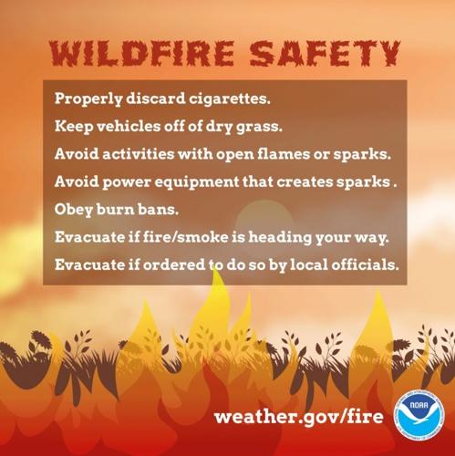
The wildfire safety tips above come from the National Oceanic and Atmospheric Administration and apply today and tomorrow. A Fire Weather Watch (below) has been issued for tomorrow which means a Red Flag event is likely in the next three days. The text below is from NWS Louisville:
A FIRE WEATHER WATCH MEANS THAT CRITICAL FIRE WEATHER CONDITIONS
ARE FORECAST TO OCCUR. LISTEN FOR LATER FORECASTS AND POSSIBLE
RED FLAG WARNINGS

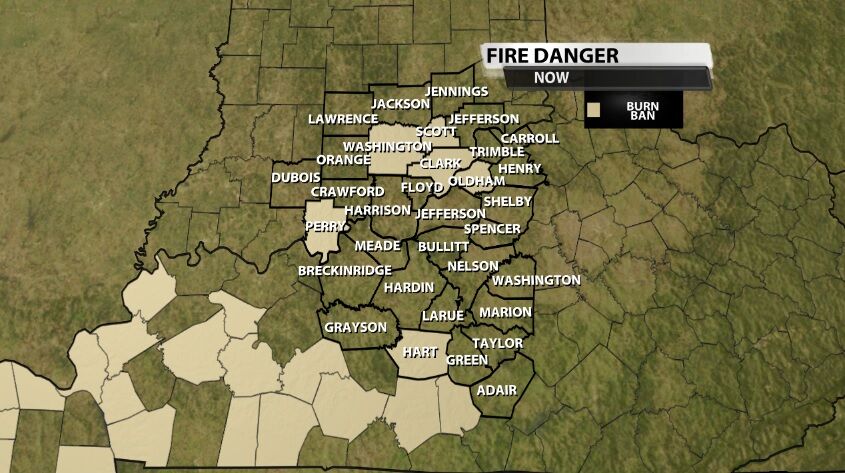
Burn Ban (below): These are a little different because they are issued by the county. Your emergency manager, fire chief, Judge-Executive, or town legislative body will be the one to issue this (not us at the TV station or the National Weather Service); Indiana and Kentucky handle these differently, and the person responsible for issuing this may be different from county to county. However Burn Bans are enforceable by law enforcement while the Red Flag Warning and Fire Weather Watch are not.
Oldham County issued theirs this afternoon with a statement that read, "At the request of the Oldham County Fire Chiefs, effective immediately, due to the extreme dry conditions that exist in Oldham County, a total ban on all outdoor burning is now in effect in Oldham County. This ban will be in effect until further notice."
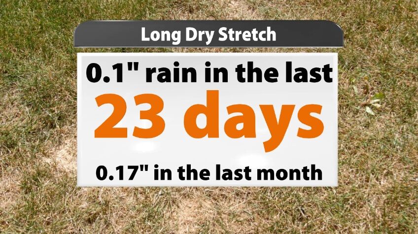
As the wind slows down a bit this weekend, the Red Flag Warning and Fire Weather Watch are expected to not be needed. However, the Burn Bans are likely going to last longer, and we expect to see more issued in the coming days. The dryness of the air is large part of the reason for these statements and alerts about the potential for wildfires. The dryness of the ground also factors in to these decision. In the last 23 days, Louisville has only measured a tenth of an inch of rain. If you expand that to the last month, it's still less than two tenths of an inch.
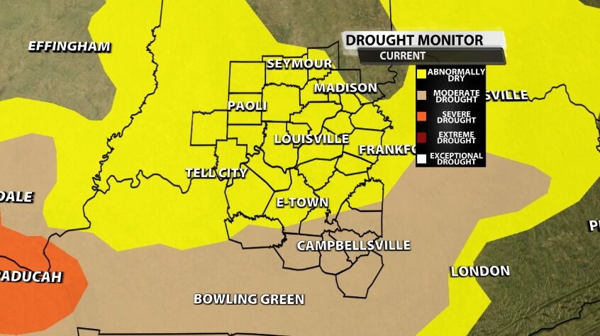
The updated Drought Monitor issued Thursday morning includes nearly our whole area in the lowest category, Abnormally Dry. Additionally, our southern communities have been "upgraded" to the Moderate Drought level in beige.
There are a few rain chances in the forecast, but they will likely not be enough to break this drought in the near future. Tune in to WDRB News starting at 4 PM to see those upcoming rain chances and hear our thoughts about how much help those will bring.


