June and July have brought some pretty hot days across our area, and we have plenty more 90-degree days coming up in the forecast. The question we are getting asked a lot lately is how unusual is this heat?
June, July, and August are considered "summer" for meteorological record keeping. So far this summer we have tied or broken these daily temperature records at the Louisville airport where records are kept and measurements taken:
- June 13 high
- June 13 warm low
- June 14 high
- June 14 warm low
- June 15 warm low
- June 16 warm low
- June 22 high
- July 1 warm low
- July 5 warm low
- all time warmest low temperature in the month of June
Even with all of those new records, the month of June didn't even rank as the top 10 warmest. The warmest June based on average temperature was 2010 with an average monthly temp of 81.1. In 2022 the average monthly temperature was 78.2 which is 1.8 degrees above normal. The tenth warmest June had an average temperature of 78.5, so 2022 didn't even break the top 10 list. Through the first 15 days in July, our average monthly temperature is 82.2. If that number holds, that would be tied for the seventh warmest July on record. Other records to watch for over the next few weeks will include warmest July and warmest summer, in addition to any daily records that we will update you about in your daily forecasts. The warmest summer in Louisville was 2010 which had an average temperature of 82.3.

Climate Central
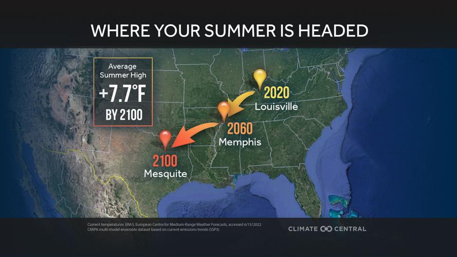
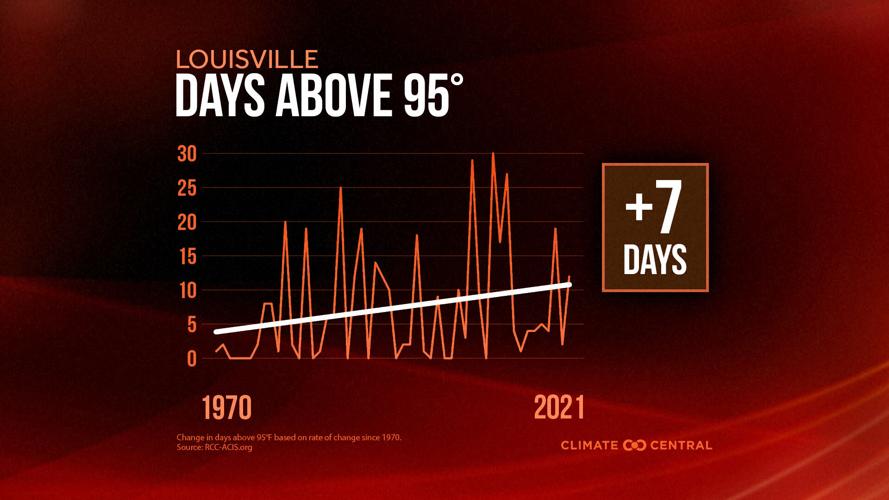
Climate Central has been studying summer heat across the country and how it affects Louisville. Climate Central evaluated 246 U.S. locations and calculated how many more days each year were "extremely hot" from 1970 to 2021, based on the 95th percentile of the average maximum summer temperature rounded up to the nearest 5 degrees. In Louisville that threshold was 95, and their research shows we are seeing on average 7 more days with that level of heat in the summer compared to what we experienced in 1970. They also projected our heat out to 2100. Based on our current rate of warming, the average summer high temperature will be more than seven degrees warmer by 2100. That means Louisville in 2100 would feel more like what Mesquite, Texas, feels like right now in the summer.

Climate Central
So, yes, this summer has started off hotter than many previous years, and there's more heat on the way in the next few weeks.