
It has been 20 years since one of our most memorable weather events: the July 13th Derecho.

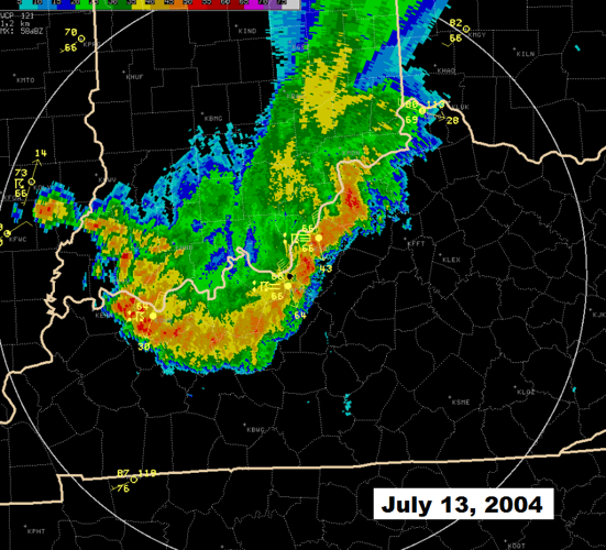
Radar image of the July 13, 2024 derecho as it moved across Kentuckiana
The National Weather Service in Louisville lists it at #9 on their list of 15 top weather events during the years of 2000-2009. As summed up by the NWS office in Louisville, "The event brought widespread wind damage to almost every county across southern Indiana and central Kentucky. It all began as tornadic thunderstorms that developed in Illinois during the afternoon. The storms then organized into a derecho that dove south across the Ohio River during the evening hours. The line of storms had a length of almost 100 miles and a forward speed of 45 to 50 mph. Widespread destructive winds ranging from 60 to 80 mph accompanied the leading edge of the storms. A wind gust of 84 mph was measured by an anemometer in Bowling Green. Winds gusted up to 65 mph in Lexington. In Louisville, power was lost to over 100,000 homes. Officials at Louisville Gas and Electric mentioned that power outages were the most widespread since the tornado of April 3, 1974. During the overnight hours, scattered severe thunderstorms continued to develop within an unstable air mass, mainly producing large hail."
The Storm Prediction Center defines a storm system as a derecho if its "swath of wind damage extends for more than 250 miles, includes wind gusts of at least 58 mph along most of its length, and also includes several, well-separated 75 mph or greater gusts."
Derechos are most common across the eastern half of the US. The map below breaks down how often different parts of the country experience a derecho event. Kentuckiana averages roughly one derecho every year.
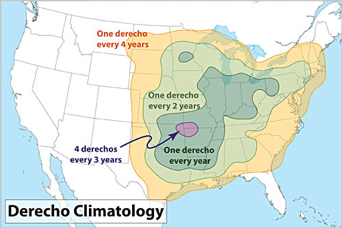
Derechos can happen at any point in the year, but they typically occur during the summer months. Once we get to August, our chance of getting a derecho goes down dramatically.

DERECHO DEVELOPMENT
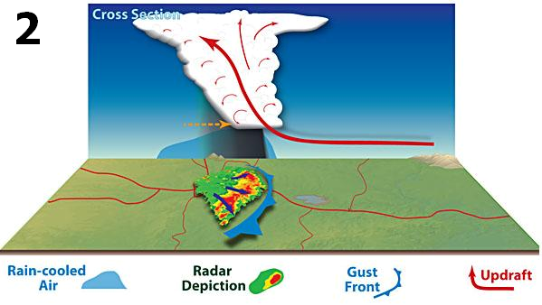
Derecho development necessarily is tied to the formation of bow echoes. A bow echo usually arises from a cluster of thunderstorms, but also may evolve from a single strong storm. Bow echoes most frequently occur when tropospheric winds are relatively strong and unidirectional (i.e., they vary little in direction with height). As the rain-cooled downdraft of a thunderstorm reaches the earth's surface, it spreads horizontally, most rapidly in the direction of the mean tropospheric flow. As the cool, dense air spreads outward, it forces the lighter, warm and moist air surrounding the storm up along the leading edge of the outflow, or gust front (see figure below, with mean flow assumed to be from left to right). The upward motion along the gust front typically is greatest along that part of the front that is moving most rapidly --- that is, progressing --- in the downwind direction (to the right in the figure). Gust fronts often are marked by low, ominous cloud formations known as arcus or shelf clouds.
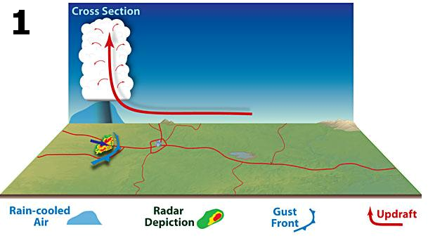
The development of a thunderstorm's downdraft ordinarily marks the dissipation stage of that particular storm. But air forced up along a gust front can give birth to new thunderstorms. As new storms mature, the rain they produce reinforces the existing "pool" of rain-cooled air produced by earlier storms, allowing the gust front to maintain its strength. As this cold pool increases in size and elongates in the direction of the mean wind, it may induce an inflow of air known as the rear-inflow jet (dashed brown arrow in figure below) on the trailing side of the thunderstorm complex. This causes the updraft to tilt toward the rear side of the storm (i.e., to the left in the figure). Tilting of the updraft allows the thunderstorm to further expand, increasing the aerial coverage of the rain. This, in turn, adds to the pool of cold air accumulating beneath the storm and strengthens the gust front, causing it to bow outward in the downwind direction. The resulting acceleration in forward motion of the gust front subsequently forces more warm, moist air upward, creating still more storms, and the process repeats.
The rain produced by the newer storms reinforces the cold pool, strengthening the inflow of air from the back side of the developing storm complex and encouraging the downward transport of higher momentum air from aloft. These processes can enable the system to attain a nearly steady-state condition. At this point, the convective system typically exhibits a pronounced bow shape on radar (see figure below) and satellite, with an area of moderate to occasionally heavy rain located near the center of the cold pool, well behind the arc of intense rain immediately behind the gust front. As long as the thermodynamic and kinematic environments support the continued development of new thunderstorm cells in the downwind direction along the advancing gust front --- a process known as downwind or "forward" propagation --- the convective complex will persist, along with the potential for downbursts and microbursts.
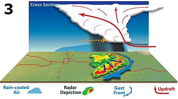
Cross section pictures modified from illustrations by Dennis Cain


