
Back on Sunday, January 16, 1994 - all eyes were glued to a rapidly changing forecast, as a potent storm was about to wallop Kentuckiana with several inches of snow by Monday morning.
Leading up to the event, the forecast had ranged from the possibility of heavy snow to a wintry mix that would feature mainly rain with only a small amount of snow during the onset of precipitation. The precipitation started falling as freezing rain during the mid-evening hours of January 16th. It came down hard and the temperature was way below freezing. The ice accumulated for a few hours, before it finally changed over to snow shortly before midnight on the 17th.

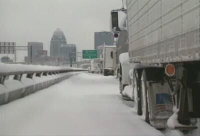
When all was said and done, a band of particularly heavy snow set up from Shelbyville through Cynthiana where nearly two feet fell. At Louisville, a single-day snowfall record of more than 15 inches was set! That all happened in about 8 hours, too!

The heavy snow set the stage for what was to come next. Behind the storm an intensely cold air mass dumped south out of Canada, sending temperatures plunging well below zero by Wednesday the 19th. Not only did Louisville record an all-time low of -22 degrees, but Shelbyville set a new record low temperature for the entire state of Kentucky with a reading of -37!


