
It is an acronym, standing for "Stratocumulus Under Deck". The National Weather Service defines them as small, ragged, low cloud fragments that are unattached to a larger cloud base and often seen with and behind cold fronts and thunderstorm gust fronts. Such clouds generally are associated with cool moist air, such as thunderstorm outflow.
While they can look scary, these clouds are usually harmless. How can you tell the difference? Well, for starters these clouds do not rotate. If you stare at it long enough, you will notice the cloud getting dragged along the base. Scud will also never have a debris field like a tornado would. Finally, there's usually other clouds that take on a similar appearance which should help put you at ease. However, depending on the circumstances, they can indicate a strong thunderstorm is in the vicinity.
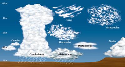
Clouds are classified according to their height above and appearance (texture) from the ground.
The following cloud roots and translations summarize the components of this classification system:
1) Cirro-: curl of hair, high.
2) Alto-: mid.
3) Strato-: layer.
4) Nimbo-: rain, precipitation.
5) Cumulo-: heap.

Image Credit: NOAA