

After a week of weather madness, the NWS has completed the surveys of now six tornadoes that touched down in our area the night of April 2nd into the morning of April 3rd. Here are the four that have been confirmed along with their stats:
Lawrence County
An EF-0 was confirmed in Lawrence county from that night, peaking at 80mph winds near the Heltonville, IN area. It was a very brief tornado and was only on the ground for 0.06 miles and was only 20 yards wide. It was roughly on the ground only for 1 minute or less. The NWS in their report stated "A brief tornado damaged a pole barn near the intersection of State Route 446 and Mundell Church Road. The south facing wall of the pole barn was the only wall left standing with damage from the barn to the west of the structure. Two 2x4s were also embedded into the ground facing to the west-northwest."

Louisville
As most of you know, the tornado that moved through Jeffersontown last week in Louisville was rated an EF-3 at max strength along the Ampere Drive area. It reached max winds of 145mph and was on the ground for 9.68 miles. The tornado was 350 yards wide at its peak. The NWS in their report stated "The tornado intensified along Ampere Court and Ampere Drive. The northeast side of a brick institutional building was completely blown out. Trees were uprooted and insulation was thrown in multiple directions. A large metal building had a failure of X-braces in the lateral load resisting system. Metal pieces and insulation were thrown into trees and road signs. Immediately next-door, at KEP electric there was a complete destruction of another building, which had a brick bottom half and a metal top half, and the metal and insulation was thrown in every direction, some of which traveled close to a mile. This was the strongest part of the tornado, and it only maintained this strength briefly. Tornado wind speeds were between 140 and 145 mph, EF3, with a width of 200 yards in this area. Some very subtle terrain is noted on topographic maps just west southwest of this area as well as a relative clearing of buildings, and these factors may briefly have influenced the strength of the tornado."
For more specifics on where it began and ended and where it did damage, visit our blog from Tuesday here.

Washington/Scott County
The same night, another tornado did damage near South Boston, Indiana in Washington county. This one was the longest tracked tornado in our area that night, being on the ground for 15.76 miles! It peaked at EF-2 strength with 115mph winds and 600 yards wide. The NWS in their report stated "The worst damage was near Conway Community Church near South Boston. The church had significant roof damage, with many gravestones in the adjacent cemetery knocked over. Just west of this location and next to the water tower, a single wide mobile home was rolled about 75 yards north and completely destroyed. A chest freezer was picked up from here and thrown 100 yards northeast into the cemetery. A conservative estimate of the wind speed here is 115 mph."
"Additional widespread damage occurred along New Salem Rd. north of Hwy 160 where a swath of trees fell. Another mobile home was rolled upside down, likely in the inflow to this tornado. Just north of that location a barn roof was crumpled and another barn was destroyed. This area likely saw high end ef1 winds. The tornado continued northeast to the end of Calloway Rd. where some structures were damaged but a very clear path of trees were snapped."

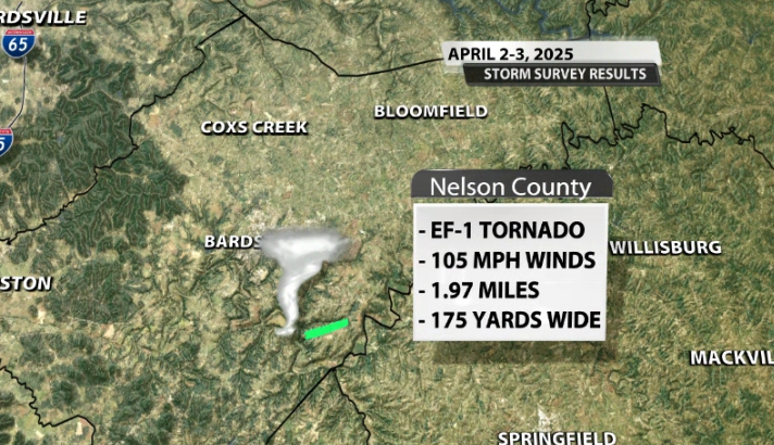
Nelson County
The most recent tornado to be confirmed was in eastern Nelson County, southeast of Bardstown. This tornado did EF-1 damage at its peak with 105mph winds. It was on the ground for 1.97 miles and was 175 yards wide at its peak. The nws in their report stated "The tornado touched down along a hilltop between Beech Fork and Pottershop Road, uprooting several trees. As the tornado approached Pottershop Road, significant damage was done to several barns and outbuildings, and large tree limbs were snapped. The most substantial damage that occurred in this area was to a small outbuilding, where only one wall was left standing as debris from this building was thrown 100-200 yards downstream. An adjacent house only sustained minor fascia and soffit damage, although brick columns on one side of the house had slightly buckled due to the wind. Wind speeds in this area were estimated at 105 mph." "The tornado then crossed Pottershop Road and moved along Bear Creek Way for approximately three-quarters of a mile. Scattered instances of snapped or uprooted trees were observed along this stretch of the tornado`s path, and several homes received minor roof damage. In addition, multiple barns and small outbuildings received more significant damage, including one well-built barn which had its entire roof collapse. Damage in this area was consistent with EF1 tornado strength, generally between 90 and 100 mph. The tornado continued to produce isolated to scattered tree damage between the end of Bear Creek Way and Manton Road as it continued to the east-northeast. Just past Manton Road, the tornado damaged multiple older barns, lean-tos and trees. Between Manton Road and Borders Lane, the tornado lifted and no significant additional damage was found downstream. The damage at the end of the tornado`s path was consistent with high-end EF0 and low-end EF1 levels, generally between 85-95 mph."
Taylor County
As of 3:30pm Wednesday, the NWS has now confirmed a FIFTH tornado in our area. This survey is still ongoing, but the NWS has already confirmed EF-1 damage with 110mph winds near the Green River Lake area in Taylor County.

New Albany
As of Wednesday afternoon, the NWS has gone back and re-surveyed another area near New Albany and confirmed a SIXTH tornado in our area from last Wednesday's storms. This was an area that was previously just thought to have 70-75mph wind gusts. They found an EF-1 tornado with 100mph winds that was on the ground for 2.24 miles and was 500 yards wide. The NWS in their report stated "The tornado first touched down just west of Green Valley Rd near Green Brier Dr. Multiple wooden power poles on the north side of the tornado were snapped toward the southeast. Some tree damage was noted over Holy Trinity Cemetery and a nearby neighborhood to the east. The tornado continued east northeast across a fairly flat area within and south of New Albany Community Park. More notable damage occurred in a WSW to ENE swath south of Castlewood Dr, roughly from Woodbourne Dr to Klerner Ln. Grace Lutheran Preschool had tree damage on the property as well as a dumpster moved 15 to 20 feet. Multiple trees were downed along Klerner Ln, where the tornado appeared to lift, per damage reports we have received. The sporadic damage paths found south of the tornado likely were inflow winds into the tornado, including damage identified by the survey team downstream of Green Valley Elementary, over Daisy Ln and Kent Dr and over to Klerner Ln at Charlestown Rd. The National Weather Service would like to thank the Floyd County Emergency Management and the Highlander Fire Department for helping us with the archived data, as well as TV news reports that assisted with documenting the damage right after it happened. Repair teams had cleaned up a lot of the electrical power pole damage as well as the tree damage before the survey team arrived."


