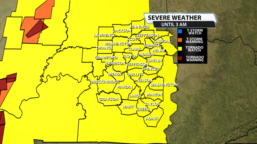


The NWS Storm Prediction Center has issued a
* Tornado Watch for portions of
Central and Southern Indiana
Central and Northern Kentucky
* Effective this Sunday night and Monday morning from 825 PM
until 300 AM EDT.
* Primary threats include...
A couple tornadoes possible
Widespread damaging winds and isolated significant gusts to 80
mph likely
SUMMARY...A severe squall line is forecast to rapidly move
east-northeast across the Watch area this evening into tonight.
Damaging gusts will likely be the most prevalent hazard, but a
couple of tornadoes are also possible with embedded mesovortices
within the squall line.
The tornado watch area is approximately along and 60 statute miles
east and west of a line from 20 miles east northeast of Lafayette IN
to 25 miles southeast of Bowling Green KY. For a complete depiction
of the watch see the associated watch outline update (WOUS64 KWNS
WOU8).
PRECAUTIONARY/PREPAREDNESS ACTIONS...
REMEMBER...A Tornado Watch means conditions are favorable for
tornadoes and severe thunderstorms in and close to the watch
area. Persons in these areas should be on the lookout for
threatening weather conditions and listen for later statements
and possible warnings.


