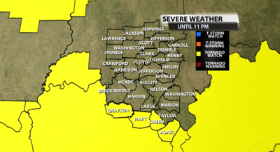

A new tornado watch has been issued for a small part of our viewing area for storms that are heading our way later this afternoon and evening. This is for our far southern communities in KY, specifically Grayson, Hart, Green, & Adair counties. The watch is in effect until 11PM ET May 20, 2025.

Here's more from the SPC on the watch...
* Effective this Tuesday afternoon and evening from 235 PM until
1000 PM CDT.
* Primary threats include...
A few tornadoes likely with a couple intense tornadoes possible
Scattered large hail likely with isolated very large hail events
to 2.5 inches in diameter possible
Scattered damaging wind gusts to 70 mph likely
SUMMARY...Thunderstorms will spread quickly eastward across the
watch area through the afternoon and early evening hours. Damaging
winds, large hail, and a few tornadoes are expected.
 REMEMBER...A Tornado Watch means conditions are favorable for
   tornadoes and severe thunderstorms in and close to the watch
   area. Persons in these areas should be on the lookout for
   threatening weather conditions and listen for later statements
   and possible warnings.


