

In Kentuckiana, we see all different kinds of weather and precipitation types. This week, it has of course been all rain, but we get it all from severe thunderstorms to blizzards! We will see snow, rain, sleet, freezing rain, graupel, and hail...but what is the difference between all of these main precipitation types? It can be important to know the difference, especially this time of the year! Let's explain!
RAIN
Rain made of liquid water droplets falls when temperatures in the air and at the surface are above freezing (32°F, 0°C). Rain can start as water droplets or ice crystals in a cloud but always falls as liquid water.
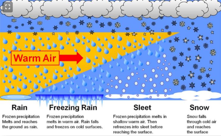
Image Credit: NOAA
SNOW
Most precipitation that forms in wintertime clouds starts out as snow because the top layer of the cloud is usually cold enough to create snowflakes. Snowflakes are just collections of ice crystals that cling to each other as they fall toward the ground. Precipitation continues to fall as snow when the temperature remains at or below 0 degrees Celsius from the cloud base to the ground. If you look at snowflakes closely, you can see their unique and beautiful shapes.
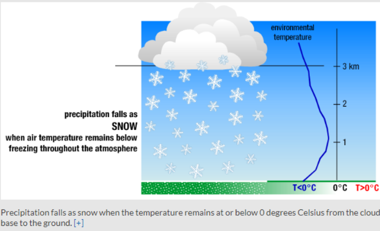
Image Credit: NOAA
- Snow Flurries. Light snow falling for short durations. No accumulation or light dusting is all that is expected.
- Snow Showers. Snow falling at varying intensities for brief periods of time. Some accumulation is possible.
- Snow Squalls. Brief, intense snow showers accompanied by strong, gusty winds. Accumulation may be significant. Snow squalls are best known in the Great Lakes Region.
- Blowing Snow. Wind-driven snow that reduces visibility and causes significant drifting. Blowing snow may be snow that is falling and/or loose snow on the ground picked up by the wind.
- Blizzards. Winds over 35mph with snow and blowing snow, reducing visibility to 1/4 mile or less for at least 3 hours.
Hail
The balls of ice that fall from clouds and can even put dents in cars are known as hail. Hail is created in thunderstorm clouds. Hailstones are formed when raindrops are carried upward by thunderstorm updrafts into extremely cold areas of the atmosphere and freeze. They then grow by colliding with liquid water drops that freeze onto the hailstone’s surface. If the water freezes instantaneously when colliding with the hailstone, cloudy ice will form as air bubbles will be trapped in the newly formed ice. However, if the water freezes slowly, the air bubbles can escape and the new ice will be clear. The hail falls when the thunderstorm's updraft can no longer support the weight of the hailstone, which can occur if the stone becomes large enough or the updraft weakens.
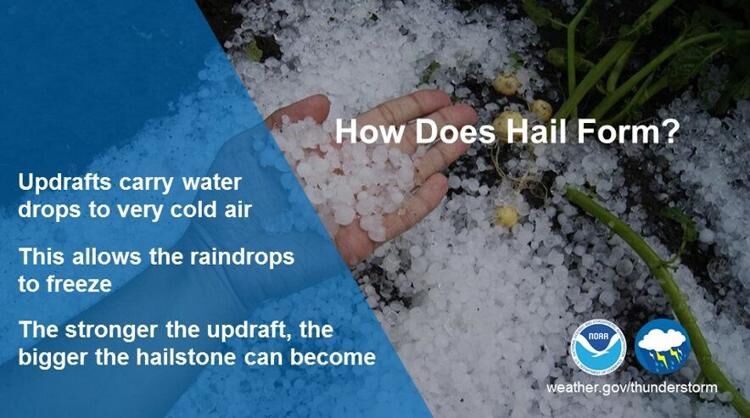
Image Credit: NOAA
Sleet
Sleet has a beat! Sleet is noisy when it falls because the icy precipitation forms when a thin layer of warmer air comes between layers of cold air. A top layer of below-freezing air creates ice crystals that melt as they fall through a thin layer of above-freezing air. If there's enough room between the warmer air and the ground, the water droplets re-freeze in a bottom layer of below-freezing air and fall as sleet.
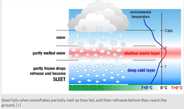
Image Credit: NOAA
Freezing Rain
Freezing rain falls like rain, but as soon as it touches the ground, it freezes! It can create a sheet of ice and a lot of problems on the ground. Freezing rain occurs when snowflakes descend into a warmer layer of air and melt completely. When these liquid water drops fall through another thin layer of freezing air just above the surface, they don't have enough time to refreeze before reaching the ground. Because they are “supercooled,” they instantly refreeze upon contact with anything that that is at or below 0 degrees C, creating a glaze of ice on the ground, trees, power lines, or other objects.
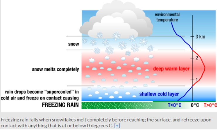
Image Credit: NOAA
Graupel
Graupel is a frosty kind of snow. They are soft, small pellets formed when supercooled water droplets (at a temperature below 32°F) freeze onto a snow crystal, a process called riming. If the riming is particularly intense, the rimed snow crystal can grow to an appreciable size, but remain less than 0.2 inches. The water droplets freeze loosely onto the snow, giving graupel a soft slushy texture. Graupel is also called snow pellets or soft hail, as the graupel particles are particularly fragile and generally disintegrate when handled. You can remember this precipitation type because the pellets often look like Dippin' Dots ice cream.
WDRB Meteorologist Bryce Jones put together a great explanation using our augmented reality graphics to help show you the difference between rain, sleet, snow, and freezing rain. You can watch that here:


