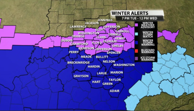


As we were in a winter storm watch earlier, the NWS has upgraded part of our area to a winter storm warning and left others in a winter weather advisory instead. These are both in effect from 7 p.m. Tuesday through noon Wednesday.

Those included in the winter storm warning are shaded in blue, while those left in a winter weather advisory are in the purple. Here's the text associated with the counties in blue from the NWS:
- WINTER STORM WARNING IN EFFECT FROM 6 PM CST /7 PM EST/ TUESDAY
- TO 11 AM CST /NOON EST/ WEDNESDAY...
- WHAT...Heavy snow expected. Total snow accumulations of 4 to 6 inches with locally higher amounts possible.
- WHERE...Portions of Indiana and east central, north central, northwest, and south central Kentucky.
- WHEN...From 6 PM CST /7 PM EST/ Tuesday to 11 AM CST /noon EST/Wednesday.
- IMPACTS...Plan on slippery road conditions. The hazardous conditions could impact the Wednesday morning and evening commutes
For those included in the winter weather advisory (purple shade), here's the text from the NWS:
- WINTER WEATHER ADVISORY IN EFFECT FROM 7 PM TUESDAY TO NOON EST
- WEDNESDAY...
- WHAT...Snow expected. Total snow accumulations between 2 and 3 inches.
- WHERE...Portions of south central Indiana and east central and north central Kentucky.
- WHEN...From 7 PM Tuesday to noon EST Wednesday.
- IMPACTS...Plan on slippery road conditions. The hazardous conditions could impact the Wednesday morning and evening commutes.
We will have updated snow totals starting on WDRB News at 4pm as the forecast continues to shift.


