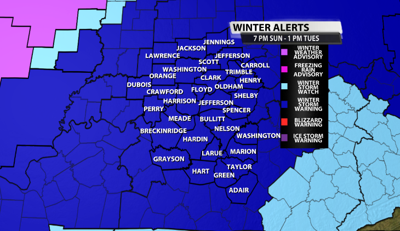
The National Weather Service in Louisville has issued a WINTER STORM WARNING for all of Kentuckiana. It goes into effect at 7 PM EST this evening until 1 pm Tuesday. This warning is actually cut up into two parts, due to the fact our northwestern communities will see sleet and snow, while our southeastern communities will see snow, sleet plus freezing rain. Totals of ice and snow will be different in these areas.

THE FIRST PART OF THE WARNING IS FOR OUR NORTHWESTERN COMMUNITIES, ALONG OF NORTH OF THE PARKWAYS
* WHERE...South central Indiana and central Kentucky along and north of the Bluegrass and Western Kentucky Parkways. Including the cities of Paoli, Salem, Scottsburg, Madison, Jasper, English, Tell City, Corydon, New Albany, Jeffersonville, Lewisport, Hawesville, Hardinsburg, Brandenburg, Hartford, Leitchfield, Elizabethtown, Shepherdsville, Louisville, La Grange, Bedford, Milton, New Castle, Shelbyville, Frankfort, Georgetown, Cynthiana, Taylorsville, Lawrenceburg, Bardstown, and Morgantown.
* WHAT...Heavy snow expected. First wave Monday morning will bring 1 to 3 inches, with the second wave Monday afternoon through Tuesday morning bringing 3 to 5 inches. Total snow accumulations of 4 to 8 inches...with locally higher amounts.
THE SECOND PART OF THE WARNING IS FOR OUR SOUTHEASTERN COMMUNITIES:
* WHERE...Portions of central Kentucky south of the Bluegrass and Western Kentucky Parkways. Including the cities of Versailles, Lexington, Paris, Carlisle, Springfield, Harrodsburg, Nicholasville, Winchester, Hodgenville, Lebanon, Danville, Lancaster, Richmond, Brownsville, Horse Cave, Greensburg, Campbellsville, Liberty, Stanford, Russellville, Bowling Green, Franklin, Providence, Scottsville, Glasgow, Tompkinsville, Edmonton, Columbia, Jamestown, Burkesville, and Albany.
WHAT...Heavy mixed precipitation expected. Total snow and sleet accumulations of 3 to 7 inches and ice accumulations between a light glaze and a quarter of an inch.
IMPACTS...
Travel could be very difficult to impossible...especially Monday afternoon through Tuesday morning.
PRECAUTIONARY/PREPAREDNESS ACTIONS...
If you must travel, keep an extra flashlight, food, and water in your vehicle in case of an emergency.