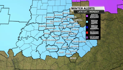
...WINTER STORM WATCH IN EFFECT FROM LATE SATURDAY NIGHT THROUGH
MONDAY AFTERNOON...

* WHAT...A wintry mix of snow, sleet, and freezing rain is expected
  from early Sunday through Monday afternoon.  Snow and sleet
  amounts of greater than 4 inches and significant ice accumulations
  of greater than a quarter of an inch are expected in the watch
  area.

* WHERE...All of southern Indiana and the norther half of central
  Kentucky.

* WHEN...From late Saturday night through Monday afternoon.

* IMPACTS...Travel is expected to become slick and hazardous on
  Sunday and continue into Monday.  Travel may become impossible at
  times Sunday afternoon and evening.  Significant ice accumulations
  across portions of the watch area may result in tree and power
  line damage.  Power outages will be possible.
Reach meteorologist Rick DeLuca at RDeluca@wdrb.com, on Twitter or on Facebook. Copyright 2024. WDRB Media. All rights reserved.