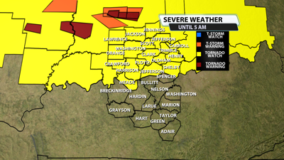

The NWS Storm Prediction Center has issued a
* Tornado Watch for portions of
Southeast Illinois
Southern Indiana
Central into Northern Kentucky
Southwest into Southern Ohio
* Effective this Wednesday night and Thursday morning from 1010
PM until 500 AM EDT.
* Primary threats include...
A few tornadoes likely with a couple intense tornadoes possible
Scattered damaging winds and isolated significant gusts to 75
mph likely
Isolated large hail events to 1.5 inches in diameter possible

SUMMARY...A cluster of supercells will move east into the Watch area
late this evening into tonight. The supercells will be capable of a
few tornadoes, including the possibility for strong tornadoes given
the intense flow fields aloft. Scattered damaging gusts are also
possible and may become more prevalent tonight as a mix of a linear
cluster and supercells probably evolves.
The tornado watch area is approximately along and 55 statute miles
north and south of a line from 80 miles east of Cincinnati OH to 65
miles northwest of Evansville IN. For a complete depiction of the
watch see the associated watch outline update (WOUS64 KWNS WOU7).
PRECAUTIONARY/PREPAREDNESS ACTIONS...
REMEMBER...A Tornado Watch means conditions are favorable for
tornadoes and severe thunderstorms in and close to the watch
area. Persons in these areas should be on the lookout for
threatening weather conditions and listen for later statements
and possible warnings.


