The Creek Fire started Friday evening, September 4, and the smoke is doing some incredible things. People flying by on planes are snapping pictures that look more like a bomb than a fire, and the plume can be see from space!
I took this today from our Southwest flight from San Jose to Las Vegas pic.twitter.com/QfWYTr6sh7
— Thalia Dockery (@SweetBrown_Shug) September 6, 2020
The picture above is called a "pyro-cumulo-nimbus" cloud: pyro meaning fire, cumulus are the big puffy clouds you normally see in the lower levels of the atmosphere, and nimbus is the note thunderstorms get to separate them from other types of clouds. What you're seeing here is just fascinating, and it's at least 50,000 feet in the air!

Image Credit: NWS
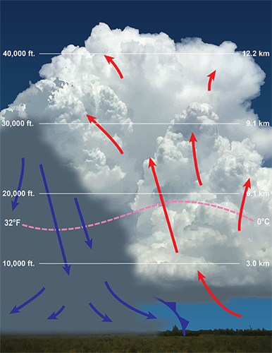
Thunderstorms are fed by ingesting warm air; that's what helps them grow. As a thunderstorm grows, it spreads up. When tracking storms here in Kentuckiana, we often show you how tall the clouds are to help gauge whether or not they are still growing. The same principle applies here. The cloud basically starts on the "cloud floor" - it can't go any lower, just like when you're walking on the floor, your foot can't go any lower. From there the cloud has to move up.
But just like the cloud has a floor, the cloud also has a ceiling. There is a level in the atmosphere that once the thunderstorm hits it, it can't really grow any taller. That's often why you see really strong thunderstorms spread out at the top like a blacksmith's anvil (they're called anvil clouds for this reason). Compare our special pyrocumulonimbus cloud to a "normal" (not fire-induced) thunderstorm cloud in the image below.
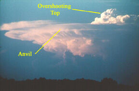
Image Credit: National Severe Storms Laboratory via NWS
The strongest storms, though, can punch through that ceiling a little bit, and that's what we see happening with the pyrocumulonimbus cloud from the Creek Fire. Take another look at the picture in the tweet at the top of this page. See how the puffy part of the cloud is continuing to build above the flat-looking part? That shows just how strong this thunderstorm is - it just punched through the ceiling and is still growing! That's called an overshooting top, and while it's not unheard of, it doesn't happen with every strong thunderstorm. It's happening here because the air feeding this thunderstorm is so hot; there's too much energy and not enough room for it to spread out.
The Creek Fire showing no signs of slowing down today. The pyrocumulonimbus plume has already produced a few lightning strikes this morning. pic.twitter.com/Yj9xe8XilC
— Dakota Smith (@weatherdak) September 6, 2020
As if that wasn't enough, you can see the pyrocumulonimbus cloud from space! You're looking at clouds from the same fire in the loop below. You can even see a few lightning flashes, confirming this is a thunderstorm fueled by the wildfire.
The Creek Fire started burning Friday evening in the Sierra National Forest in central California near Fresno. More than 200 people had to be airlifted from the Mammoth Pool Reservoir Saturday as the fire rapidly spread, cutting off evacuation routes. That's a popular recreation area and people were asked to shelter in place Saturday when the fire crossed the San Joaquin River into this area, according to the Fresno Bee.
Simply extraordinary, lifesaving work by the @CalGuard airlifting more than 200 people to safety overnight from the imminent danger of the #CreekFire The National Guard stands Always Ready, Always There to support our communities and nation in times of need. pic.twitter.com/MybDKESipJ
— General Daniel Hokanson (@ChiefNGB) September 6, 2020
The fire is in a river valley right now, but the wind in that environment will help the fire spread. We know warm air rises (it's less dense), so the wildfire warms the air A LOT and the air is forced to rise quickly. That creates an up-slope wind coming out of the river valley. That up-slope wind will help the fire climb the sides of the ravine and continue spreading outside the valley.
Here's another weather impact: the National Weather Service has issued an Excessive Heat Warning through Monday night because a "prolonged period of dangerously hot temperatures is expected." They are forecasting high temperatures between 105ºF and 112ºF in this area Monday afternoon, not because of the fire but because that's just how hot the air will be in the region anyway! That level of heat on top of heat from the blaze will make it incredibly difficult for firefighters to fight the Creek Fire Monday.
The Creek Fire is currently 0% contained and has burned more than 45,000 acres. That brings the total California acreage burned already this year to more than 1 million; in fact, it's getting closer to 2 million. Last year at this same period in the season, fewer than 30,000 acres had burned. This wildfire season in California will go down in history.


