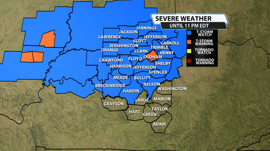


The NWS Storm Prediction Center has issued a
* Severe Thunderstorm Watch for portions of
Southern Illinois
Southern Indiana
Northern Kentucky
* Effective this Saturday afternoon and evening from 445 PM until
1100 PM EDT.
* Primary threats include...
Scattered damaging wind gusts to 70 mph possible
Scattered large hail events to 1.5 inches in diameter possible
SUMMARY...Strong to severe thunderstorms are expected to increase in
coverage this afternoon and evening within the moist and unstable
environment in place from southern Illinois into southern Indiana
and northern Kentucky. The strongest storms within this region will
be capable of large hail and/or damaging gusts.
The severe thunderstorm watch area is approximately along and 60
statute miles north and south of a line from 40 miles west southwest
of Salem IL to 65 miles northeast of Louisville KY. For a complete
depiction of the watch see the associated watch outline update
(WOUS64 KWNS WOU8).
PRECAUTIONARY/PREPAREDNESS ACTIONS...
REMEMBER...A Severe Thunderstorm Watch means conditions are
favorable for severe thunderstorms in and close to the watch area.
Persons in these areas should be on the lookout for threatening
weather conditions and listen for later statements and possible
warnings. Severe thunderstorms can and occasionally do produce
tornadoes.
&&
AVIATION...A few severe thunderstorms with hail surface and aloft to
1.5 inches. Extreme turbulence and surface wind gusts to 60 knots. A
few cumulonimbi with maximum tops to 550. Mean storm motion vector
25020.


