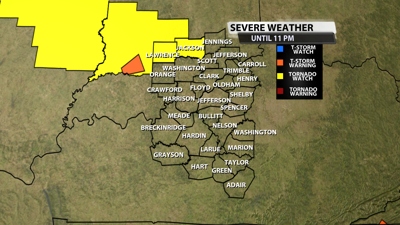

The NWS Storm Prediction Center has issued a
* Tornado Watch for portions of
Southern and Central Illinois
Central and Southern Indiana
East-Central Missouri
* Effective this Wednesday afternoon and evening from 440 PM
until 1000 PM CDT.

* Primary threats include...
A couple tornadoes possible
Scattered damaging wind gusts to 70 mph possible
Scattered large hail events to 1.5 inches in diameter possible
SUMMARY...Widely scattered thunderstorms are forecast to develop and
intensify late this afternoon into the evening in the vicinity of a
west to east oriented boundary. A few supercells are expected and a
couple of tornadoes are possible. Severe gusts and large hail are
also possible.
The tornado watch area is approximately along and 40 statute miles
north and south of a line from 50 miles west of Saint Louis MO to 25
miles east of Bloomington IN. For a complete depiction of the watch
see the associated watch outline update (WOUS64 KWNS WOU0).
PRECAUTIONARY/PREPAREDNESS ACTIONS...
REMEMBER...A Tornado Watch means conditions are favorable for
tornadoes and severe thunderstorms in and close to the watch
area. Persons in these areas should be on the lookout for
threatening weather conditions and listen for later statements
and possible warnings.


