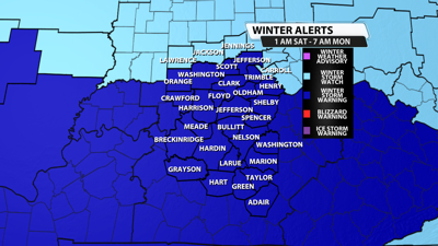


...WINTER STORM WARNING IN EFFECT FROM 1 AM EST /MIDNIGHT CST/
SATURDAY TO 7 AM EST /6 AM CST/ MONDAY...
* WHAT...Heavy snow mixed with sleet and freezing rain along and
south of the Bluegrass and Western Kentucky Parkways. South of the
parkways, storm total snow and sleet 4 to 10 inches with up to a
third of an inch of ice accumulation. North of the parkways mainly
snow, heavy at times. Total snow accumulations between 10 and 14
inches. Locazlized higher amounts possible.
* WHERE...Portions of south central Indiana and east central, north
central, northwest, and south central Kentucky.
* WHEN...From 1 AM EST /midnight CST/ Saturday to 7 AM EST /6 AM
CST/ Monday.
Weather Forecast | Live Cams | Radar | Share Photos & Videos
* IMPACTS...Travel could be very difficult to impossible.
PRECAUTIONARY/PREPAREDNESS ACTIONS...
If you must travel, keep an extra flashlight, food, and water in
your vehicle in case of an emergency. In Indiana, for Indiana Road
Conditions please visit http://511in.org In Kentucky, for Kentucky
Road Conditions please visit http://goky.ky.gov
More coverage:
Winter storm updates | How to stay prepared when winter weather hits the Louisville area
'Millions of Americans prepare for potentially catastrophic ice storm. Here’s what the numbers show
JCPS cancels all weekend events as forecast promises significant winter storm
INDOT preparing for weekend winter storm as timing, temperatures become key factors
Kentuckiana shoppers stock up on salt, supplies ahead of winter storm


