


LOUISVILLE, Ky. (WDRB) -- Kentucky Gov. Andy Beshear has declared a state of emergency for the Commonwealth ahead of expected severe weather.
The severe storms are expected to continue through Sunday, according to a news release. There is a potential for historic amounts of rain, strong winds and a possibility of tornadoes. Western Kentucky is facing a a Level 5 severe weather risk, meaning there could be widespread severe storms.
Beshear encouraged Kentuckians to find a safe place to stay Wednesday as tornadoes, hail, flooding and strong winds are expected.
"Tornadoes are expected, and I know that’s tough to hear. And we are most concerned about the area of Western Kentucky that has gotten hit far too much, as well as a wider area of Western Kentucky," Beshear said in a news release. "Remember, these can be strong tornadoes, EF-2 and greater. We’re really concerned about people’s safety, especially in the overnight, because when storms or tornadoes hit while people are asleep, that’s sadly when we’ve lost the most people. So, everybody out there, be really careful."
Kentucky, we're under some of the most serious weather threats I've seen. We need everyone statewide to take this seriously. Tonight, we expect tornadoes, dangerous winds and hail. You need to be prepared. Have alerts on, an emergency kit ready and stay elsewhere if safer. 1/2 pic.twitter.com/ywMlBJuKyZ
— Governor Andy Beshear (@GovAndyBeshear) April 2, 2025
The Kentucky Emergency Operations Center has been activated and units of the Kentucky National Guard are ready to respond.
Beshear also implemented the state's price gouging laws to protect Kentuckians from overpriced goods and services as they clean up and recover from the storm. Consumers can report price gouging to the Office of the Attorney General by clicking here.
Louisville Mayor Craig Greenberg said one of the most important things you can do now is to sign up for emergency notifications by texting "LensAlert" to 67283. Once you've signed up, you'll be notified about severe weather so you don't have to rely on hearing warning sirens.
It's also a good idea to make sure you have flashlights and batteries. Keep phones and other devices fully charged, and try to have three days' worth of water and non-perishable food on hand.
Drivers are again reminded not to drive through standing water. Just six inches of moving water can sweep a vehicle off the road.
The Louisville Metro Police Department is also preparing for the wet weather and possible incoming floods.
Officers said they're ready with dive teams if needed as the river water levels rise over the next week even after the rain comes through.
They're urging extreme caution around rivers and larger ponds and especially near and under viaducts. If drivers aren't sure how deep the water is on roadways, never risk it.
"Don't drive into standing water, don't go around barricades," LMPD Chief Paul Humphrey said. "You all would be surprised how many people drive around blocked streets and barricades and marked police cars with lights on in order to flood their cars out. It's an extremely dangerous situation. Don't win a Darwin award on this. It's not worth it. You're not going to get through the flood water"
If you come across flooding in the Metro area, MSD reminds people to report it to "311" or the MSD hotline 520-540-6000.
Area Emergency Shelters
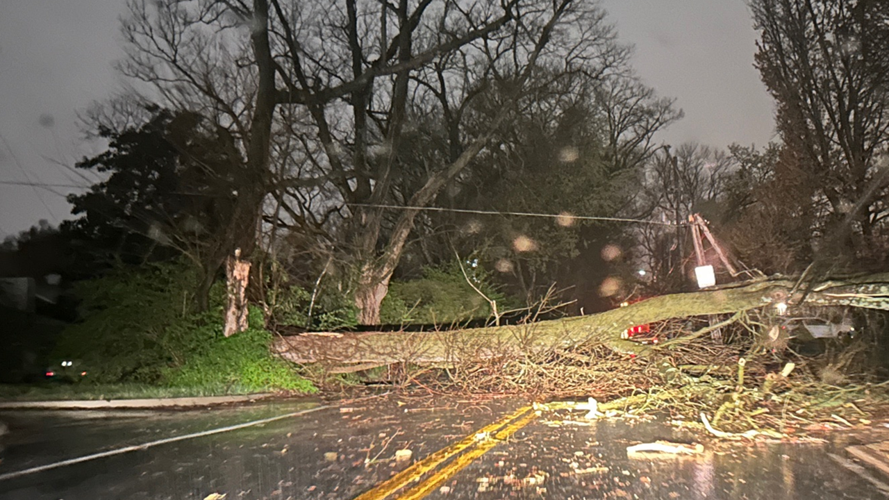
Residents across the area are still recovering after five tornadoes touched down in four Kentucky counties on Sunday. No serious injuries were reported, but trees and power lines were toppled, and homes and other property were damaged.
As the area prepares for more storms Wednesday, many counties in the Kentuckiana area are setting up emergency shelters.
In Bullitt County, the Emergency Management Agency said several shelters will open at 5 p.m. Wednesday and will serve as a tornado shelter and flooding evacuation shelter, if necessary. For additional information, call 502-543-2000.
- North Bullitt High School, 3200 E. Hebron Lane
- Bullitt East High School, 11450 Highway 44 E
- Lebanon Junction Elementary, 10920 S. Preston Highway
- Nichols Elementary, 10665 Highway 44 W
- Roby Elementary, 1148 Highway 44 E
- Shepherdsville City Hall, 634 Conestoga Parkway, will be utilized if Roby is at full capacity.
In Breckinridge County, the Old Courthouse at 208 S. Main Street, Hardinsburg, will be open as a storm shelter.
In Spencer County, there are three storm shelter locations:
- Little Union Baptist Church
- 4620 Little Union Road, Taylorsville KY 40071
- First Baptist Church
- 115 W.Main St, Taylorsville KY 40071
- Ridgeview Baptist Church
- 10 Dogwood Circle, Taylorsville KY 40071
In Salem, Indiana, there will be a safe room open Wednesday night at Salem Middle School located at 1001 N. Harrison St.
In West Point, Kentucky, the West Point school building will open at 8:30 p.m. and remain open until about midnight. The building can't accommodate pets and isn't a certified storm shelter.
First responder preparations
With the risk of serious flooding, first responders are on standby ready to help.
One of the biggest stressors from first responders isn't to estimate the force and power of water. The NWS said six inches of water is enough to knock over an adult.
"We've been practicing making sure all of our equipment gets checked," Anchorage Middletown Fire and EMs Special Operations Battalion Chief Mike Arth said.
In addition to checking its wearable equipment like fins, wetsuits and life vests, Anchorage Middletown Fire EMS has two boats ready for water rescue missions.
Agencies on both sides of the river use similar equipment. Tri-Township Fire and Rescue in southern Indiana has its own rescue boats.
Jefferson County fire departments have several water rescue teams.
"When it comes times to needing multiple agencies we work as one whole team for Jefferson County special operations," Arth said.
First responders also spend several hours behind the scenes training year round for water rescues so they can be ready to answer the call when needed.
"We're standing by, ready to go, and always prepared," Arth said.
School Decisions
Some schools have already announced their plans for classes Thursday ahead of the storms. Some schools say the 2-hour delay is to help the district assess road condition and storm damage in the daylight.
Some schools may also instead switch to synchronous or asynchronous eLearning based on what happens.
To view the list as it's updated, click here.
Download WDRB Apps
A great way to stay weather aware is to download the WDRB Weather app, which provides current and up-to-date weather notifications and alerts when severe weather comes through. Opt-in for push alerts to make sure you receive severe weather alerts as they happen. To download the app on the Apple App Store, click here. To download for Android on Google Play, click here.
For the latest forecasts and conditions from WDRB's weather team, click here.
Related Coverage:
- Louisville officials urge residents to prepare for storms, life-threatening floods in the forecast
- EF-1 tornadoes confirmed in Jefferson, Bullitt and Spencer counties from Sunday night storms
- Kentucky flooding death toll rises to 21 as recovery efforts continue
- Volunteers from Louisville provide relief for families in Pikeville after flooding
Copyright 2025 WDRB Media. All rights reserved.


