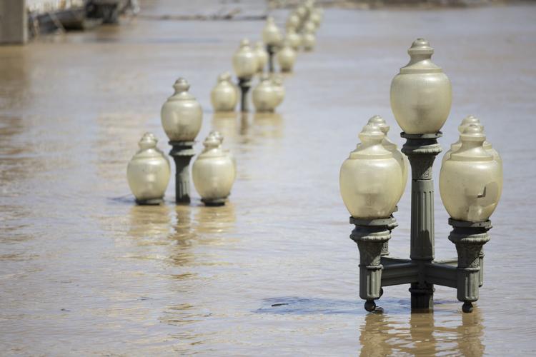
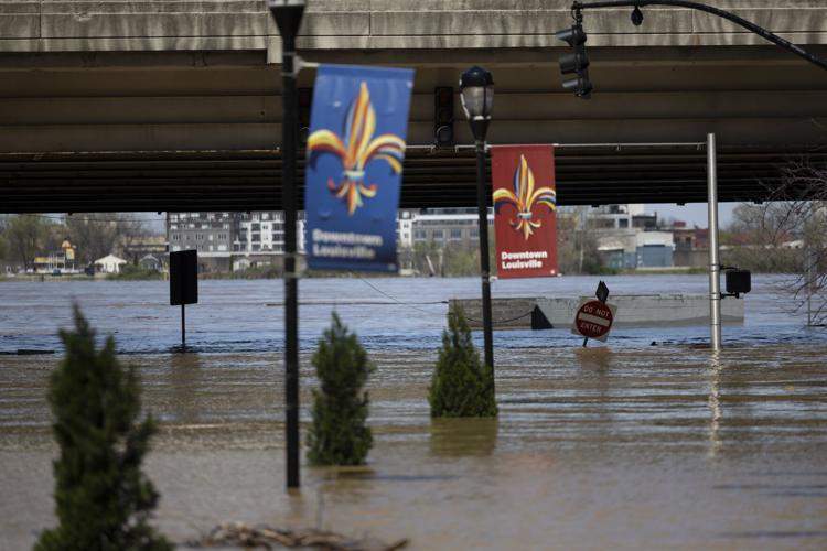
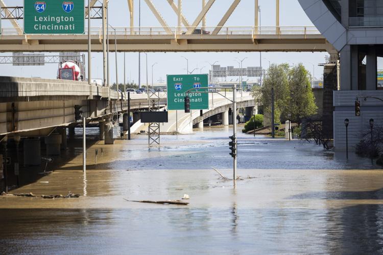


LOUISVILLE, Ky. (WDRB) -- The Ohio River in downtown Louisville is expected to crest around 8 a.m. Wednesday at 37 feet, a massive rise from the normal 12-foot pool seen at McAlpine Upper.
In a news conference Tuesday morning, Louisville Mayor Craig Greenberg said the days and days of rain in the area will result in a top-10 flooding event in the history of the city with far-reaching impacts to residents, businesses and more.
River Road has seen the most impact from the floods in Louisville, and several other surrounding counties have been hit hard. In fact, Louisville Metro Police sent rescue crews to Bullitt County to get inmates from a nearly flooded jail and transfer them to Jefferson County.
And on Monday, Louisville firefighters helped get 66 people out of a hotel that was surrounded by water.
Crews are working to minimize the rising water and will soon turn to cleanup efforts.
"Now that the rain has ended, we have opened up storm debris drop-off locations around the entire city," Greenberg said Tuesday. "... We are not going to wait for the water to recede to start cleanup."
The locations listed below are open from 2-7 p.m. April 7-11 and 8 a.m. to 7 p.m. April 12.:
- Highview Park (Briscoe Lane entrance)
- Fern Creek Park, 8703 Ferndale Road
- Shawnee Park, 4501 W. Broadway
- Tom Sawyer Park (Enter from Tom Sawyer Drive)
- Charlie Vettiner Park (Enter from Mary Dell Road)
- Hubbards Lane Recycling Center, 595 N. Hubbards Lane
- 535 Meriwether Ave.
- Fairdale Recycling Center, 10618 W. Manslick Road
- Public Works Yard, 10500 Lower River Rd. (Enter from Bethany Lane)
Below is a list of street closures in Louisville on Tuesday:
- 3rd Street/River Road/Downtown (Exit 5B) off-ramp from I-64 West
- Blankenbaker Lane at River Hill Road
- Watson Lane at Lower River Road
- Clay Street at Franklin Street
- Indian Hills Trail from River Road to 60 Indian Hills Trail
- Mockingbird Valley Road from Mockingbird Valley Place to Mellwood Avenue
- Mockingbird Valley Road at Mockingbird Valley Green
- Mellwood Avenue at Thompson Avenue
- Indian Hills Trail at Tepee Road
- Fincastle Trail from Lower River Road to dead end
- Watson Lane from Lower River Road to Dixie Highway
- River Road to Zorn Avenue
- Indian Hills Trail from River Road to Rier Bluff Road
- River Road from Rockledge Road to Wolf Pen Branch Road
- East Overbrook Drive from Lake Dreamland Road to end
- Lime Kiln Road from River Knolls Drive to River Road
- Bass Road at Hays Kennedy Park entrance
- Mellwood Avenue from Zorn Avenue to Mockingbird Valley Road
- River Road from Zorn Avenue to Mockingbird Valley Road
- Mockingbird Valley Road from Mellwood Avenue to River Road
- River Road from Mockingbird Valley Road to Indian Hills Trail
- River Road from Indian Hills Trail to Blankenbaker Lane
- Riverside Drive (entire length)
- East Riverside Drive (entire length)
- West Riverside Drive (entire length)
- Riviera Drive (entire length)
- Blankenbaker Lane from River Road to Woodside Drive
- River Road from Blankenbaker Lane to Glenview Avenue
- River Road from Glenview Avenue to Lime Kiln Lane
- Mellwood Avenue to Zorn Avenue
- Mellwood Avenue from Delmont Avenue to Muncie Avenue
- River Road at Lime Kilm Lane
- River Road at Wolf Pen Branch
- River Road at Blankenbaker Lane
- Hurstbourne Parkway at Raintree Drive
- Mockingbird Valley Road (entire length)
- Hatmaker Trail (entire length)
- Mellwood Avenue from Edith Road to Zorn Avenue
- Mellwood Avenue from Brownsboro Road to Edith Road
- South Preston Street between East Jefferson Street to Market Street
- Muhammad Ali Boulevard from Preston Street to Floyd Street
- River Road from Edith Road to Zorn Avenue
- North Zorn Avenue from River Road to Mellwood Avenue
- River Road from Frankfort Avenue to Edith Road
- Edith Road from River Road to Mellwood Avenue
- Runic Way at Rustic Way between Rangland Road and Red Oak Lane
- Seatonville Road at Brush Run Road
- Mayfair Avenue from Translvania Beach Road to the first curve
- Captains Quarters Road from River Road to end
- Harbor Town Road from River Road to end (entire length)
- Juniper Beach Road from River Road to end (entire length)
- Mockingbird Valley Road from River Road to Mellwood Avenue
- Alta Vista Road from Lexington Road to Beargrass Road
- National Turnpike from Mount Holly Road to Fairdale Road
- Grade Lane from Melton Avenue to Outer Loop
- Frankfort Avenue from River Road to Story Avenue
- Campbell Street from East Water Street to Adams Street
- North Campbell Street from Adams Street to Franklin Street
- North Campbell Street from Adams Street to Geiger Street
- Lower River Road from West Orell Road to Watson Lane
- Indian Hills Trail from River Bluff Road to River Road
- Katherine Station Road from Dixie Highway to bridge
- Adams Street from Cabel Street to East Witherspoon
- Witherspoon from North Shelby Street to River Road
- Beargrass Road from Alta Vista Road to Barrett Hill Road
- West River Road from North 3rd Street to North 8th Street
- West River Road from Bingham Way to North 7th Street
- North 2nd Street from East Witherspoon Street to West River Road
- North 6th Street from West Washington Street to West River Road
- North 4th Street from West Main Street to West River Road
- North 3rd Street from West Main Street to West River Road
This story will be updated.
Top Stories:
Frankfort's Buffalo Trace Distillery closed after 'unprecedented' flooding from Ky. River
3 dead after triple shooting in Louisville's Portland neighborhood
Louisville firefighters rescue dozens as floodwaters rise rapidly along Ohio River
Copyright 2025 WDRB Media. All Rights Reserved.


